WMO GCW home

Metadata

  • Station or cluster: CryoNet Cluster
  • Type: Basic
  • WMO ID (if any):
  • Shape: polygon
  • Latitude, longitude: 72.0, -40.0
  • Altitude and/or range (m): 0; 220-1840
  • Landscape: Coastal
  • Year established: first sites in 2001
  • Year-round? Yes
  • Operations contact: Michele Citterio
  • Science contact: Dirk van As
  • Data contact: Signe Andersen
  • Click for website

Click here for Google Maps

PROMICE Greenland Ice Sheet Monitoring Network [Candidate]
Basic CryoNet Cluster Information

In 2007 the Programme for Monitoring of the Greenland Ice Sheet (PROMICE) was initiated as an ongoing effort to assess changes in the mass budget of the Greenland ice sheet. The two major contributors to the Greenland ice sheet mass loss are a reduction in the surface mass budget through enhanced surface melt and an increasing ice calving flux through glacier acceleration. PROMICE aims to quantify both these processes. The surface mass budget is monitored by a network of weather stations in the melt zone of the ice sheet, providing measurements that feed into models calculating ice-sheet-wide melt. Changes in ice dynamics are tracked using satellite imagery and on-ice GPS. In order to translate this into the mass of ice lost at the many Greenland calving glaciers, information on ice thickness is required as well. This is obtained by airborne laser and radar surveys of the entire ice sheet margin. In addition, changes in the extent of the ice sheet and the many local ice caps and glaciers in Greenland are monitored through with satellite imagery.

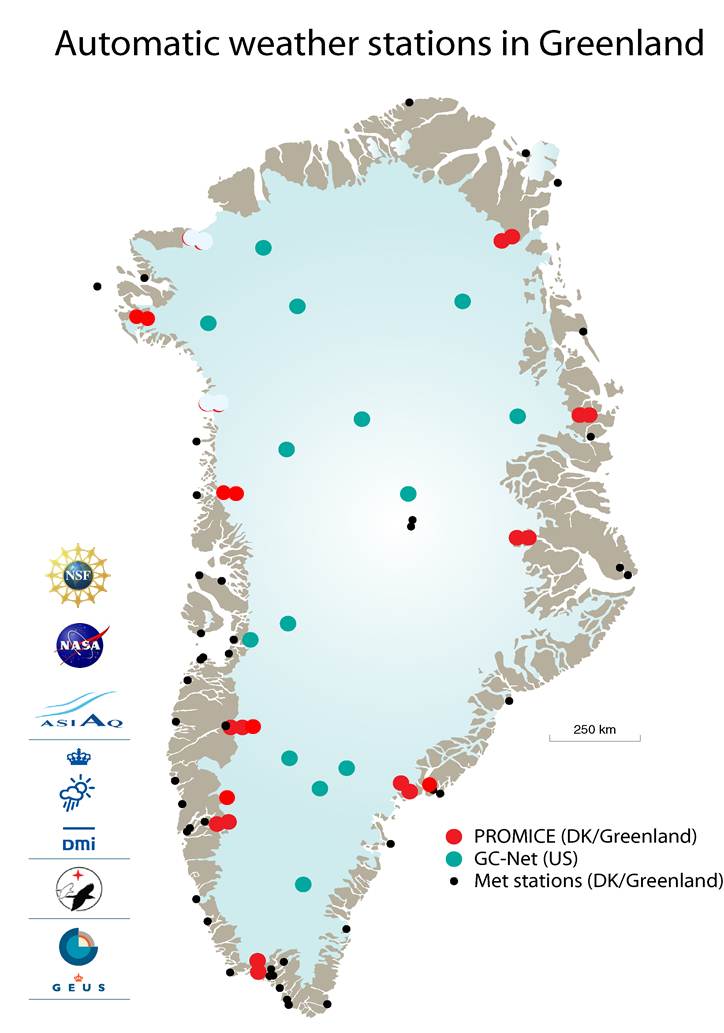
The PROMICE network on the ground is composed of seven transects encompassing the margin of the Greenland Ice Sheet. Each transect is composed by two to four automatic stations, from Thule in NW Greenland to Upernavik, Kangerlussuaq, Nuuk, and Qassimiut in West and South Greenland, to Tasiilaq, Scoresbysund and Kronprins Christian Land in East and North Greenland. Starting with 2009, Mittivakkat Glacier in East Greenland is also being monitored. Since 2007 all PROMICE stations are identical and measure air temperature, relative humidity, wind speed and direction, atmospheric pressure, incoming and outgoing short- and longwave radiation, ice temperature, surface velocity, snow depth and surface ice ablation.

Measurement Methods Used

Other relevant measurement method documents:

Given the broad scope of PROMICE, different guidelines and measurement methods are followed as far as relevant to the peculiar conditions of the Greenland Ice Sheet. Among these:

WMO, 2008, Guide to meteorological instruments and methods of observation, WMO-No. 8, World Meteorological Organization, Geneva, Switzerland.

Paul, F., R.G. Barry, J.G. Cogley, H. Frey, W. Haeberli, A. Ohmura, C.S.L. Ommanney, B. Raup, A. Rivera & M. Zemp, 2009, Recommendations for the compilation of glacier inventory data from digital sources, Annals Glaciol., 50(53), 119–126.

Østrem G. and M. Brugmann, 1991, Glacier Mass Balance Measurements. A manual for field and office work. National Hydrology Research Institute (Canada), Science Report No. 4.

Kaser, G., Fountain, A., and Jansson, P., 2003, A Manual For Monitoring the Mass Balance of Mountain Glaciers. IHP-VI Technical Documents in Hydrology No. 59, UNESCO-IHP, Paris.

Data Information

Publications

Ahlstrøm AP, Gravesen P, Andersen SB, Van As D, Citterio M, Fausto RS, Nielsen S, Jepsen HF, Kristensen SS, Christensen EL, Stenseng L, Forsberg R, Hanson S, Petersen D and PROMICE Project Team (2008) A new programme for monitoring the mass loss of the Greenland ice sheet. Geol. Surv. Denmark Greenland Bull., 15, 61-64.

Measurements

The measurements made at PROMICE Greenland Ice Sheet Monitoring Network are listed in the following tables. This is a combination of measurements made at the stations within the site, where the start and end years in the tables are the earliest and latest years of measurement. (Note: If End Year is blank, measurements are ongoing.)

Cryosphere Measurements

Element Variable Start Year End Year
SnowDepth2001
SnowAlbedo2001
GlacierAnnual mass balance2009
GlacierArea1987
GlacierVelocity2009
GlacierSurface temperature2009
GlacierSurface albedo2009
GlacierIce/firn temperature2009
IcesheetIce thickness2007
IcesheetSurface velocity2007
IcesheetInternal temperature2007
IcesheetIce margin1978
IcesheetSurface elevation2007
IcesheetSurface temperature2007
IcesheetSurface albedo2001

Atmosphere Measurements

Element Variable Start Year End Year
MetAir temperature2001
MetHumidity/vapour pressure2001
MetWind speed and direction2001
MetAir pressure2001
RadiationDownwelling shortwave2001
RadiationUpwelling shortwave2001
RadiationDownwelling longwave2001
RadiationUpwelling longwave2007

Measurement Notes and Other Measurements

Category Description or List
SnowSnow water equivalent (SWE): we started in 2012 experimenting with automatically monitoring SWE at selected sites using "Snowpack Analyzers" by Sommer (Austria). This is not currently operational.
GlacierSince 2009 PROMICE includes one station outside the Greenland Ice Sheet, on Mittivakkat Glacier in East Greenland.

Glacier area: PROMICE is mapping glaciers on an ongoing base and produced a complete map of all Greenland glaciers and ice caps: Citterio M and Ahlstrøm AP (2013) Brief communication "The aerophotogrammetric map of Greenland ice masses". The Cryosphere, 7, 445-449 (doi: 10.5194/tc-7-445-2013).

In general, given the logistic constraints of maintaining sensors in remote areas, there are occasional gaps in the tieseries, particularly before the esablishment of PROMICE as a network in 2007.

IcesheetCoincident airborne radar ice thickness and lidar surface elevation over a full round-trip of the Greenland ice sheet (designed to map the flux gates) in 2007 and in 2011, with a new repetition scheduled for 2015 or 2016.

Surface velocity on the ground with GPS trackers and from space using SAR. GPS also gives continuous surface elevations but the accuracy is limiting for glaciological applications.

Mapping of the ice margin is an ongoing task given the size of Greenland. Most of the aerophotographs are from 1978-1987, with regions having older poorly documented coverage and optical remote sensing being used for recent dates (mostly Landsat 7-8 and ASTER).

In general, given the logistic constraints of maintaining sensors in remote areas, there are occasional gaps in the tieseries, particularly before the esablishment of PROMICE as a network in 2007. Surface albedo is sporadic before 2007.

AtmosphereGiven the logistic constraints of maintaining sensors in remote areas, occasional gaps can exist also in the time series of those parameters with a target of continuous observations, particularly before the esablishment of PROMICE as a network in 2007. Surface albedo and the other radiation parameters are sporadic before 2007.

Last updated: 31 May 2017