 |
Metadata
|
 |
AWS1 FORNI
Reference CryoNet Station Information
Other Networks to Which This CryoNet Station Belongs
- WMO - SPICE (Solid Precipitation Intercomparison Experiment) Network
- SHARE (Station ay High Altitude for Research on the Environment) Network
- GEWEX (Global Energy and Water Cycle Experiment)
- ESA Project 31873 (PI D. Fugazza)
- ESA Project 32535 (PI L. Vezzola)
Measurement Methods Used
- WMO Technical Regulations
Other relevant measurement method documents:
Snow thickness and water equivalent are manually performed following AINEVA protocol
Field ice ablation measurements are performed following IAHS (ICSI) - UNEP - UNESCO methods
Meltwater discharge measurements are in agreement with the standard methods suggested by IAHS (International Association Hydrological Sciences)
Data Information
- Are the data quality controlled? yes
- How are the data accessible? FTP, an existing data center
- Data availability (may depend on the variable measured): in near real-time, delayed less than one month, delayed less than one year
Publications
1. Citterio, M., Diolaiuti, G., Smiraglia, C., Verza, G., and Meraldi, E. (2007) - Initial results from the Automatic Weather Station (AWS) on the ablation tongue of Forni Glacier (Upper Valtellina, Italy). Geografia Fisica e Dinamica Quaternaria, 30, 141–151.
2. Senese A., Diolaiuti G., Mihalcea C. & Smiraglia C. (2010) – Evoluzione meteorologica sulla lingua di ablazione del Ghiacciaio dei Forni (Lombardia, gruppo Ortles-Cevedale) nel periodo 2006-2008. Bollettino della Società Geografica Italiana (BSGI), Roma, Serie XIII, vol. III, fascicolo 4, pp. 845-864. (Meteorological evolution on the ablation zone of Forni Glacier, Ortles-Cevedale Group [Stelvio National Park, Italian Alps] during the period 2006-2008).
3. Diolaiuti G., Senese A., Mihalcea C., Verza G.P., Mosconi B. and Smiraglia C. (2011) – AWS measurements on glaciers in the Italian Alps. In “Workshop on the use of automatic measuring systems on glaciers. Extended abstracts and recommendations.” IASC Workshop, 23-26March 2011, Pontesina (Switzerland). Organized by C.H. Tijm-Reijmer and J. Oerlemans.
4. Senese A., Diolaiuti G., Mihalcea C. and Smiraglia C. (2012) – Energy and mass balance of Forni Glacier (Stelvio National Park, Italian Alps) from a 4-year meteorological data record. Arctic, Antarctic, and Alpine Research, 44 (1), 122-134.
5. Senese A., Diolaiuti G., Verza G.P. and Smiraglia C. (2012) – Surface energy budget and melt amount for the years 2009 and 2010 at the Forni Glacier (Italian Alps, Lombardy). Geografia Fisica e Dinamica Quaternaria, 35 (1), 69-77. DOI 10.4461/GFDQ.2012.35.7
6. Gambelli S., A. Senese, C. D’agata, C. Smiraglia and G. Diolaiuti (2014) - Preliminary analysis for distribution of the surface energy budget of the Forni Glacier, Valtellina (Ortles-Cevedale Group, Italy). Geografia Fisica e Dinamica Quaternaria, 37(1), 15-22. DOI 10.4461/GFDQ.2014.37.2
7. Garavaglia R., A. Marzorati, G.e Confortola, D. Bocchiola, G. Cola, E. Manzata, A. Senese, C. Smiraglia e G.A. Diolaiuti (2014) - Evoluzione del Ghiacciaio dei Forni. Neve & Valanghe, 81, 60-67.
8. Senese A., M. Maugeri, E. Vuillermoz, C. Smiraglia, and G. Diolaiuti (2014) - Using daily air temperature thresholds to evaluate snow melting occurrence and amount on Alpine glaciers by T -index models: the case study of the Forni Glacier (Italy). The Cryosphere, 8, 1921–1933. doi:10.5194/tc-8-1921-2014
9. Senese A., Vuillermoz E., Azzoni R.S., Verza G.P., Smiraglia C. and Diolaiuti G. (2015) - Air Temperature Thresholds to Assess Snow Melt at the Forni Glacier Surface (Italian Alps) in the April–June Period: A Contribution to the Application of Temperature Index Models. In G. Lollino et al. (eds.), Engineering Geology for Society and Territory, Volume 1, pp 61-68. Springer International Publishing Switzerland 2015. DOI: 10.1007/978-3-319-09300-0_12
10. Azzoni R.S., A. Senese, A. Zerboni, M. Maugeri, C. Smiraglia, G. Diolaiuti (2016) - Estimating ice albedo from fine debris cover quantified by a semi-automatic method: the case study of Forni Glacier, Italian Alps. The Cryosphere, 10, 665–679. doi:10.5194/tc-10-665-2016. Available online at http://www.the-cryosphere.net/10/665/2016/tc-10-665-2016.pdf
11. Fugazza D., Senese A., Azzoni R.S., Maugeri M. and Diolaiuti G.A. (2016) - Spatial distribution of surface albedo at the Forni Glacier (Stelvio National Park, Central Italian Alps). Cold Regions Science and Technology 125, 128–137.
12. Fugazza D., Senese A., Azzoni R.S., Smiraglia C., Cernuschi M., Severi D. and Diolaiuti G.A. (2015) - High-resolution mapping of glacier surface features. The UAV survey of the forni Glacier (Stelvio National Park, Italy). Geogr. Fis. Dinam. Quat., 38(1) , 25-33.
13. Franzetti A., Tagliaferri I., Gandolfi I., Bestetti G., Minora U., Mayer C., Azzoni R.S., Diolaiuti G., Smiraglia C. and Ambrosini, R. (2016) – Light-dependent microbial metabolisms drive carbon fluxes on glacier surfaces. The ISME journal, 1-5.
14. Senese A., Maugeri M., Ferrari S., Confortola G., Bocchiola D. and G. Diolaiuti (accepted) - Modelling shortwave and longwave downward radiation and air temperature driving ablation at the Forni Glacier (Stelvio National Park, Italy). Geogr. Fis. Dinam. Quat.
Additional Information Documents
Measurements
The measurements made at AWS1 FORNI are listed in the following tables. (Note: If End Year is blank, measurements are ongoing.)
Cryosphere Measurements
| Atmosphere Measurements
|
Measurement Notes and Other Measurements
| Category | Description or List |
|---|---|
| Snow | In addition to automatic snow measurements acquired by the AWS1 Forni, from 2005 snow depth and density are periodically measured. From 2014 snow chemistry and microbiology are studied in collaboration with researchers from University of Milano-BICOCCA, which periodically have been sampling snow, firn and meltwater. |
| Atmosphere | As regards turbulent fluxes (sensible and latent) and sunshine duration, data are not directly measured but they are derived. In particular, turbulent fluxes are estimated from bulk equations (see Senese et al., 2012) and sunshine duration is deducted from incoming solar radiation dataset. |
| Hydrology | An automatic hydrometer (radar sensor) was installed under a bridge along the main glacier meltstream in summer 2011 thus providing high resolution data on meltwater discharge. |
| Ecology | Samples of snow, ice and meltwater are periodically acquired to detect presence of pollutants, of microbial matter and micro- and meso-fauna. |

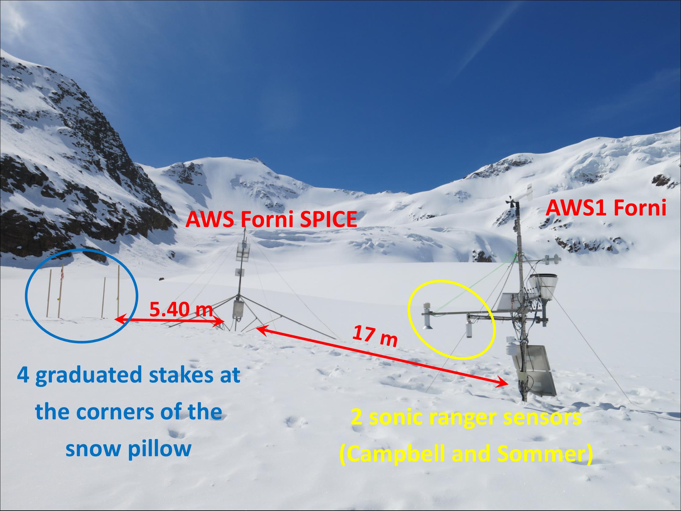
In May 2014 for the insertion of the AWS1 Forni in SPICE project, i) another sonic ranger (Sommer USH-8), ii) a snow pillow for measuring snow water equivalent (Park Mechanical) with graduated stakes at the four corners, and iii) an automatic camera (this latter acquiring pictures with hourly resolution of the four stakes) were installed. For supporting these new sensors, a second mast as the one above described was installed near by the AWS1 Forni.
Supraglacial morphologies (bedieres) may develop at the AWSs location, which can compromise the stability. In this case, the AWSs need to be moved to a more stable surface. The height where instruments are placed was chosen in order to permit their activity also during the wintertime when snow covers the glacier surface and partially buries the AWS mast.
The AWS1 Forni is online through a radio link and a GSM modem. More precisely a first radio has been installed at the AWS site and another one was installed on a hut located in the ski resort named Plaghera, easily accessible both in winter and in summer by car, and where we have installed also a GSM modem. Both the radio devices have amplified their signal by directive antennas. The communication system at the AWS site is supported by a dedicated solar panel and a gel battery 30 Ah. Instead, at the Plaghera hut radio and modem are supplied by a permanent 220 V system. The radio devices we use are synthesized radio modem devices, compatible with personal computer, working in UHF band (380 - 470 MHz) in half-duplex manner; the transfer speed ranges from 300 to 38.400 bit/sec and the modulation in air is equal to 19.200 bps (25 kHz channel) or 9.600 bps. The number of covered channels corresponds to a total band of 2 MHz at ±1 MHz from the chosen frequency. Then the connection is possible every hour per day for 10 minutes. In fact, to allow a remote-control and a remote-download, the AWS is scheduled to switch on the radio every hour for 10 minutes. During this time frame is possible to call the GSM modem and then the AWS.
For the GCW network, we will take advantage from this already running communication system thus having the possibility of a daily quality check of the installed instruments and of a daily data downloading. After the download process the all data are subjected to a quality check and a validation procedure, and are stored in a data base. The access to this data base will be through a FTP site (ftp://users.unimi.it/).
Summarizing, the AWS1 Forni is : i) permanently equipped, ii) permanently accessible via GSM-radio link and data are daily downloaded and stored into a dedicated FTP site, iii) periodically visited, thus providing high resolution data (also featuring a very good accuracy) to be use for calibration and validation of glaciological and climatological models. In addition, these data support studies and investigations on the Forni glacier (mainly modelling approaches devoted to describe glacier energy budget, mass balance, ice flow and dynamics).
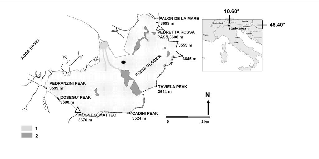
The AWS1 Forni is located at the melting surface of the Forni Glacier. This latter is the largest Italian valley glacier (c. 11.36 km2 of surface area in the Ortles-Cevedale group, Stelvio National Park, Central Italian Alps). The glacier presents a North aspect and an elevation range between 2600 and 3670 m a.s.l. Forni Glacier is included in the official “Geosites Inventory” of the Sondrio Province, Lombardy Region (Italy) and is located in areas identified as SICs (Sites of Community Importance) according to the 92/43/CEE.
The land cover in the area is dominated by glaciers. More precisely the Stelvio National Park, where the Forni Glacier is located, is in the Lombardy sector and covers about 600 km2, while the glaciers cover c. 40 km2 (7% of the park area) and Forni Glacier is the largest one. The other areas are covered for the largest part by forests and Alpine grasslands even if villages and traffic occur. The Forni Glacier is c. 8 km far from the nearest village, Santa Caterina Valfurva (1728 m a.s.l.).