 |
Metadata
|
 |
Mocho-Choshuenco Volcano
Contributing Station Information
Other Networks to Which This Contributing Station Belongs
- The Mocho-Choshuenco glacier monitoring programme is part of Chile's General Water Directorate (DGA) network, Tier 2 (pilot glacier).
Measurement Methods Used
- UNESCO
Other relevant measurement method documents:
Cogley, J.G., Hock, R., Rasmussen, L.A., Arendt, A.A., Bauder, A., Braithwaite, R.J., Jansson, P., Kaser, G., Möller, M., Nicholson, L. and Zemp, M., 2010, Glossary of Glacier Mass Balance and Related Terms. IHP-VII Technical Documents in Hydrology No. 86, IACS Contribution No. 2, UNESCO-IHP, Paris. 114 pp.
Data Information
- Are the data quality controlled? yes
- How are the data accessible? other
- Data availability (may depend on the variable measured): delayed less than one year
Publications
Bown, F., A. Rivera, C. Acuña & G. Casassa. 2007. Recent glacier mass balance calculations at Volcán Mocho-Choshuenco (40ºS), Chilean Lake District. IAHS Publ. 318, 143-152.
Rivera A., Bown F., Casassa G., Acuña C., Clavero J. 2005. Glacier shrinkage and negative mass balance in the Chilean Lake District (40°S). Hydrological Sciences Journal 50(6): 963-974.
Rivera, A., F. Bown, R. Mella, J. Wendt, G. Casassa, C. Acuña, E. Rignot, J. Clavero, B. Brock. 2006. Ice volumetric changes on active volcanoes in southern Chile. Annals of Glaciology, 43, 111-122.
Santibañez, P., S. Kohshima, R. Scheihing, J. Jaramillo, T. Shiraiwa, S. Matoba, H. Kanda, P. Labarca & G. Casassa. 2008. Glacier mass balance interpreted from biological analyses of firn cores in the Chilean Lake District. Journal of Glaciology, 54(186), 452-462.
Santibáñez, P.A., S. Kohshima, R. Scheihing, R. Silva, J.I. Jaramillo, P.J. Labarca and G. Casassa. 2011. First Record of Testate Amoebae on Glaciers and Description of a New Species Puytoracia jenswendti nov. sp. (Rhizaria, Euglyphida). Acta Protozool. 50, 1-14.
Measurements
The measurements made at Mocho-Choshuenco Volcano are listed in the following tables. (Note: If End Year is blank, measurements are ongoing.)
Cryosphere Measurements
| Atmosphere Measurements
|
Measurement Notes and Other Measurements
| Category | Description or List |
|---|---|
| Glacier | 10 m firn cores have been collected at an elevation of 2000 m and 2420 m, characterizing the chemistry and biology. |
| Atmosphere | Net short wave and long wave net radiometer (Kipp & Zonen NR Lite). Downwelling short wave radiation (Kipp & Zonen SP Lite). |
| Hydrology | Water level measurements with a pressure gage and data logger in an eastern stream originated at the glacier, altitude 1340 m. Several runoff measurements allow to convert water level to runoff. |
| Other | Two seismic stations exist at 1600 and 1900 m elevation, operated by Chile's Geological Survey, for monitoring volcanic activity, connected in real time as part of an early warning system. |

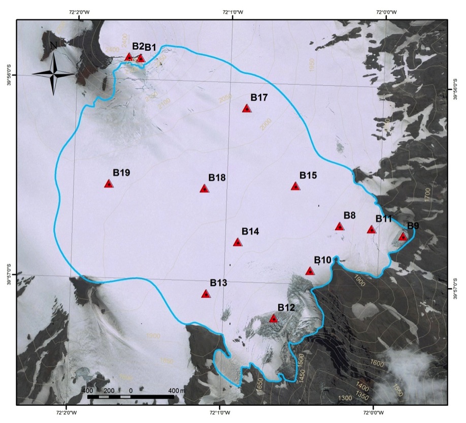
The south-eastern side of the Mocho-Choshuenco Volcano is covered by a 5.1 km2 glacier which occupies a large caldera. With the collaboration of Huilo-Huilo Foundation a mass balance monitoring programme was started on this glacier in May 2003. The traditional stake method (12 stakes) is employed for monitoring the mass balance, distributed from an elevation of 1723 m a.s.l. to 2416 m a.s.l., a few metres below the summit. 2 AWSs and an automatic river gage station have been deployed.
High precipitation (5 m to 15 m of snow) is deposited during the winter on the glacier, originating from the westerly circulation. The summer is much drier, with relevant ablation due to high temperatures and solar radiation. A high interannual variability in mass balance has been detected. The glacier is temperate, with the presence of a water table at a depth of 5-10 m. Glacier-volcanic effects are potentially very relevant. Detailed glacier thickness data have allowed to model lahar risks.