Col de Porte Reference CryoNet Station Information
The Col de Porte pilot site is located near Grenoble, in the Chartreuse massif. At this mountain site, on the flat measurements field, meteorological and snow parameters are recorded hourly since 1961. These parameters are : - Air temperature and humidity - Short- and long-wave radiations - Wind speed and precipitation - Snow depth, snow water equivalent - Settlements and snow temperatures of the different layers of the snowpack Weekly snowpack profiles are also carried out, including major stratigraphic properties of snow (temperature, density, liquid water content, snow type).
The Col de Porte site has been widely used to build and evaluate snowpack models such as Crocus, using its unique high-resolution snow and meteorological measurements. In addition, such measurements are useful to monitor the effects of climate change on the Alpine snow cover.
The site is also extremely useful for testing dedicated instrumentation, and carrying out innovative research in the field or in the cold room attached to the laboratory.
The experimental site col de Porte is linked to related observation networks such as the national glacier monitoring observatory (GLACIOCLIM) and the local snow/atmosphere observation network CENACLAM.
Other Networks to Which This CryoNet Station Belongs
The station is associated to the French glacier observation network GLLACIOCLIM and to a local (Grenoble) initiative gathering snow/atmosphere observation sites named CENACLAM. Some measurements are carried out in collaboration with EDF-DTG (French power company). The site has been contributing to the WMO-SPICE project.
Measurement Methods Used
WMO Technical Regulations
UNESCO
CIMO
Data Information
Are the data quality controlled? yes
How are the data accessible? FTP, an existing data center
Data availability (may depend on the variable measured): delayed less than one year
Publications
Morin, S., Lejeune, Y., Lesaffre, B., Panel, J.-M., Poncet, D., David, P., and Sudul, M.: An 18-yr long (1993-2011) snow and meteorological dataset from a mid-altitude mountain site (Col de Porte, France, 1325 m alt.) for driving and evaluating snowpack models, Earth Syst. Sci. Data, 4, 13-21, doi:10.5194/essd-4-13-2012, 2012
Measurements
The measurements made at Col de Porte are listed in the following tables. (Note: If End Year is blank, measurements are ongoing.)
Cryosphere Measurements
Element
Variable
Start Year
End Year
Frequency
Snow
Depth
1961
Continuous
Snow
Snow water equivalent
1961
Continuous
Snow
Snowpack profile
1961
Continuous
Snow
Snowfall depth
1961
Fragmented
Snow
Water equivalent of snowfall
1961
Fragmented
Snow
Albedo
1993
Continuous
Snow
Temperature
1993
Snow
Surface temperature
1993
Snow
Snow surface area
2010
2011
Sporadic
Frozenground
Ground temperature
1993
Atmosphere Measurements
Element
Variable
Start Year
End Year
Frequency
Met
Air temperature
1961
Continuous
Met
Humidity/vapour pressure
1993
Continuous
Met
Wind speed and direction
1993
Continuous
Met
Air pressure
1993
Continuous
Met
Snowfall
1961
Continuous
Met
Total precipitation
1961
Continuous
Met
Rainfall
1961
Continuous
Radiation
Downwelling shortwave
1993
Continuous
Radiation
Upwelling shortwave
1993
Continuous
Radiation
Downwelling longwave
1993
Continuous
Radiation
Upwelling longwave
1993
Continuous
Measurement Notes and Other Measurements
Category
Description or List
Snow
internal snow temperature using settlement disks (hourly since 1993)
Seasonally frozen ground
Soil temperature at -10, -20 and -50 cm hourly since 1993. Soil temperature and soil moisture at -5, -10, -20 and -30 cm hourly since 2012.
Hydrology
Snow runoff is measured using 2 lysimeters (1 m2 and 5 m2) at hourly time step since 1993.
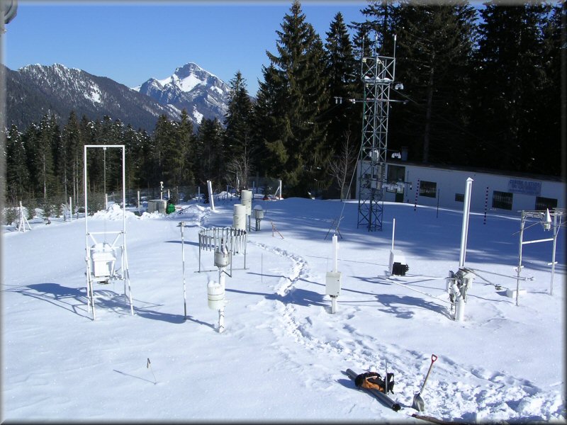

These parameters are :
- Air temperature and humidity
- Short- and long-wave radiations
- Wind speed and precipitation
- Snow depth, snow water equivalent
- Settlements and snow temperatures of the different layers of the snowpack
Weekly snowpack profiles are also carried out, including major stratigraphic properties of snow (temperature, density, liquid water content, snow type).
The Col de Porte site has been widely used to build and evaluate snowpack models such as Crocus, using its unique high-resolution snow and meteorological measurements. In addition, such measurements are useful to monitor the effects of climate change on the Alpine snow cover.
The site is also extremely useful for testing dedicated instrumentation, and carrying out innovative research in the field or in the cold room attached to the laboratory.
The experimental site col de Porte is linked to related observation networks such as the national glacier monitoring observatory (GLACIOCLIM) and the local snow/atmosphere observation network CENACLAM.