Cryosphere Now: Satellite Products
The most recent images for a variety of satellite products are shown below. They are generally 1-4 days old. Hover over a thumbnail to get the full image, description, and credits. Important: The products shown on the "Cryosphere Now" pages provide a variety of perspectives on the state of the cryosphere. They are for purposes of illustration and comparison and are not necessarily endorsed by GCW as "authoritative".
Global:
NOAA Multisensor Snow/Ice Cover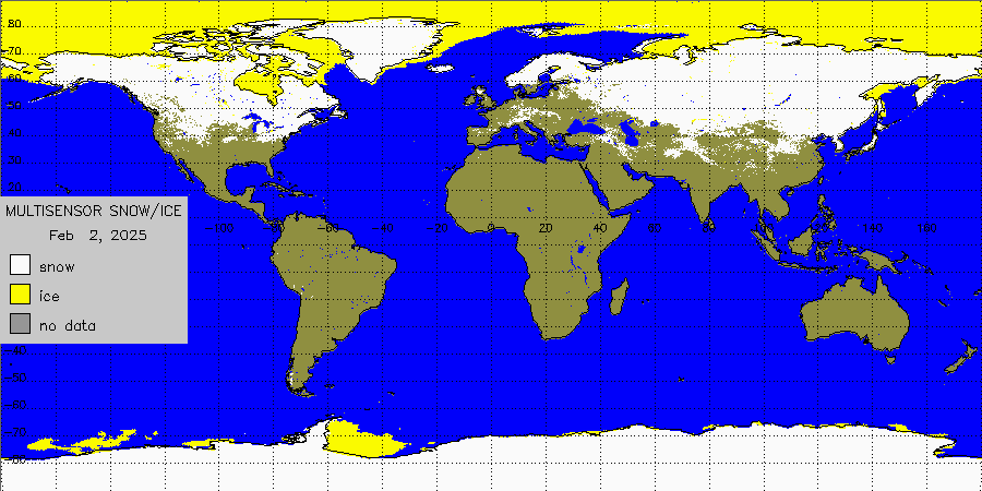 The Global Snow and Ice Cover Map is derived from combined observations of METOP AVHRR, MSG SEVIRI, GOES Imager and DMSP SSMIS. The algorithm is fully automated. This is an experimental product. It is a NOAA/NESDIS product. (Courtesy of Peter Romanov) |
Northern Hemisphere:
AMSR2 Snow & Ice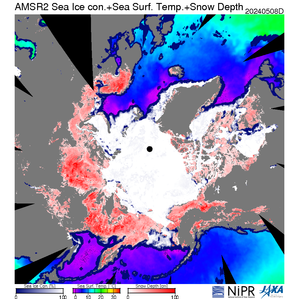 JAXA's composite image product with sea ice concentration, sea surface temperature, and snow depth on land. From AMSR2 data. More plots are available from the National Institute of Polar Research (NIPR) Arctic Data archive System (ADS). |
SSM/I Ice Concentration The SSM/I ice concentration data are from NSIDC. |
AMSR2 Ice Concentration AMSR2 ice concentration plots are from the University of Bremen. |
NPP VIIRS Ice Concentration NPP (actually, S-NPP) is the Suomi National Polar-Orbiting Partnership. These are NESDIS operational products. The images shown here are produced by the Cooperative Institute for Meteorological Satellite Studies (CIMSS) and NOAA at the University of Wisconsin-Madison. CAUTION: The VIIRS products are still being evaluated and are only considered to have a beta level of maturity. More plots are available. |
NSIDC Ice Extent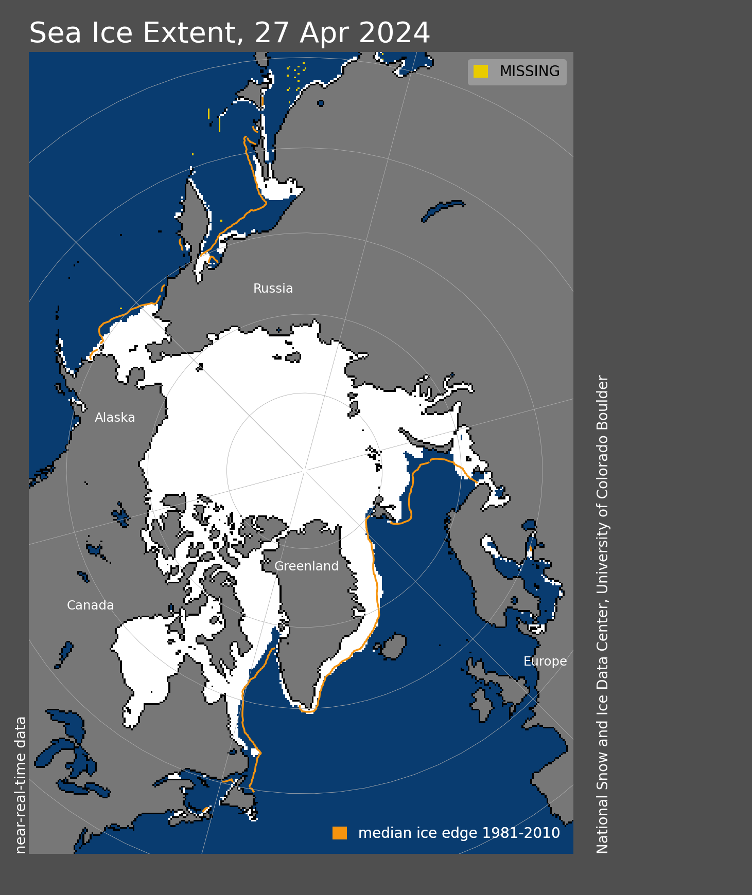 This is NSIDC's ice extent product. |
NPP VIIRS IST NPP (actually, S-NPP) is the Suomi National Polar-Orbiting Partnership. These are NESDIS operational products. The images shown here are produced by the Cooperative Institute for Meteorological Satellite Studies (CIMSS) and NOAA at the University of Wisconsin-Madison. CAUTION: The VIIRS products are still being evaluated and are only considered to have a beta level of maturity. More plots are available. |
IMS Snow Cover <  IMS is the Interactive Multi-Sensor Snow and Ice Mapping System from the National Ice Center. |
APP-x Ice Thickness Note: Thickness is not retrieved for solar zenith angles between 88 and 92 degrees. APP-x is the extended AVHRR Polar Pathfinder. It is a 30+ year product suite of twice-daily composites for the Arctic and Antarctic, updated daily (though a few days old). It is a research product and some parameters are experimental. More plots are available. |
NPP VIIRS Ice Age NPP (actually, S-NPP) is the Suomi National Polar-Orbiting Partnership. These are NESDIS operational products. The images shown here are produced by the Cooperative Institute for Meteorological Satellite Studies (CIMSS) and NOAA at the University of Wisconsin-Madison. CAUTION: The VIIRS products are still being evaluated and are only considered to have a beta level of maturity. More plots are available. |
APP-x IST APP-x is the extended AVHRR Polar Pathfinder. It is a 30+ year product suite of twice-daily composites for the Arctic and Antarctic, updated daily (though a few days old). It is a research product and some parameters are experimental. More plots are available. |
APP-x Albedo APP-x is the extended AVHRR Polar Pathfinder. It is a 30+ year product suite of twice-daily composites for the Arctic and Antarctic, updated daily (though a few days old). It is a research product and some parameters are experimental. More plots are available. |
Greenland Melt Days Greenland Melt Days is from NSIDC, based on melt data from Thomas Mote at University of Georgia, who uses SSMIS from NSIDC. |
OSI SAF Ice Drift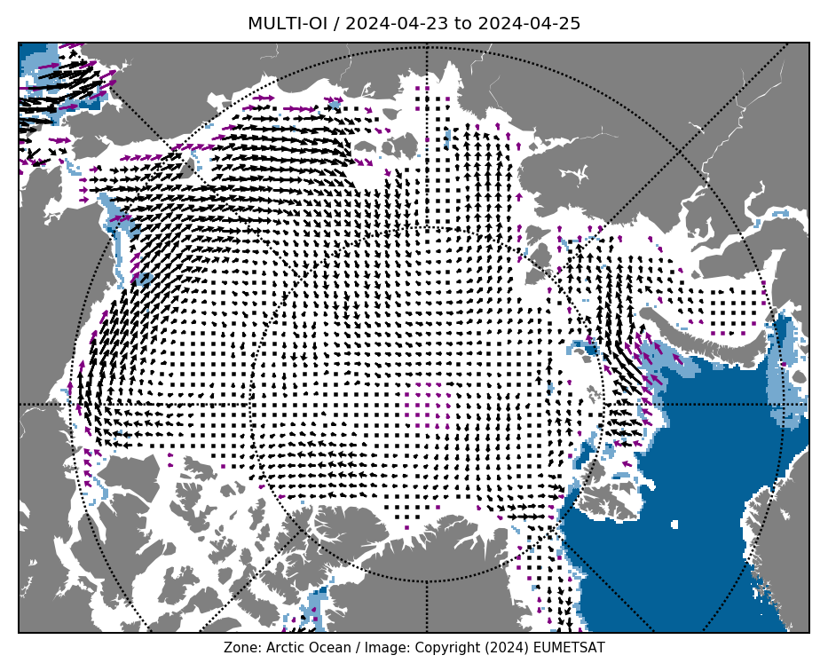 OSI SAF Ice Drift is the low resolution sea ice drift product from the EUMETSAT Ocean & Sea Ice Satellite Application Facility (OSI SAF). It is based on SSMIS and ASCAT data. |
NPP VIIRS Cloud Mask NPP (actually, S-NPP) is the Suomi National Polar-Orbiting Partnership. These are NESDIS operational products. The images shown here are produced by the Cooperative Institute for Meteorological Satellite Studies (CIMSS) and NOAA at the University of Wisconsin-Madison. CAUTION: The VIIRS products are still being evaluated and are only considered to have a beta level of maturity. More plots are available.< |
Southern Hemisphere:
AMSR2 Snow & Ice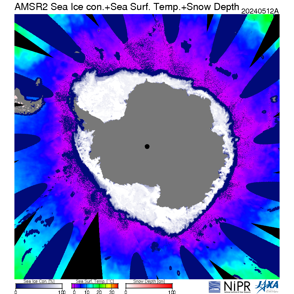 JAXA's composite image product with sea ice concentration, sea surface temperature, and snow depth on land. From AMSR2 data. More plots are available from the National Institute of Polar Research (NIPR) Arctic Data archive System (ADS). |
SSM/I Ice Concentration The SSM/I ice concentration data are from NSIDC. |
AMSR2 Ice Concentration AMSR2 ice concentration plots are from the University of Bremen. |
NPP VIIRS Ice Concentration NPP (actually, S-NPP) is the Suomi National Polar-Orbiting Partnership. These are NESDIS operational products. The images shown here are produced by the Cooperative Institute for Meteorological Satellite Studies (CIMSS) and NOAA at the University of Wisconsin-Madison. CAUTION: The VIIRS products are still being evaluated and are only considered to have a beta level of maturity. More plots are available. |
NSIDC Ice Extent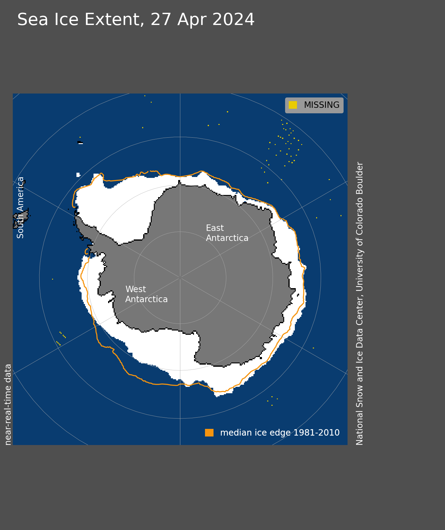 This is NSIDC's ice extent product. |
APP-x Ice Thickness Note: Thickness is not retrieved for solar zenith angles between 88 and 92 degrees. APP-x is the extended AVHRR Polar Pathfinder. It is a 30+ year product suite of twice-daily composites for the Arctic and Antarctic, updated daily (though a few days old). It is a research product and some parameters are experimental. More plots are available. |
NPP VIIRS Ice Age NPP (actually, S-NPP) is the Suomi National Polar-Orbiting Partnership. These are NESDIS operational products. The images shown here are produced by the Cooperative Institute for Meteorological Satellite Studies (CIMSS) and NOAA at the University of Wisconsin-Madison. CAUTION: The VIIRS products are still being evaluated and are only considered to have a beta level of maturity. More plots are available. |
NPP VIIRS IST NPP (actually, S-NPP) is the Suomi National Polar-Orbiting Partnership. These are NESDIS operational products. The images shown here are produced by the Cooperative Institute for Meteorological Satellite Studies (CIMSS) and NOAA at the University of Wisconsin-Madison. CAUTION: The VIIRS products are still being evaluated and are only considered to have a beta level of maturity. More plots are available. |
APP-x IST APP-x is the extended AVHRR Polar Pathfinder. It is a 30+ year product suite of twice-daily composites for the Arctic and Antarctic, updated daily (though a few days old). It is a research product and some parameters are experimental. More plots are available. |
APP-x Albedo APP-x is the extended AVHRR Polar Pathfinder. It is a 30+ year product suite of twice-daily composites for the Arctic and Antarctic, updated daily (though a few days old). It is a research product and some parameters are experimental. More plots are available. |
NPP VIIRS Cloud Mask NPP (actually, S-NPP) is the Suomi National Polar-Orbiting Partnership. These are NESDIS operational products. The images shown here are produced by the Cooperative Institute for Meteorological Satellite Studies (CIMSS) and NOAA at the University of Wisconsin-Madison. CAUTION: The VIIRS products are still being evaluated and are only considered to have a beta level of maturity. More plots are available.< |
