Snow Assessments |
 |
2014 Global Snow Cover
Cooperative Institute for Meteorological Satellite Studies, University of Wisconsin, Madison, WI, USA
[5 June 2015]
Snow cover in the cryosphere has a significant cooling effect on the global climate system. By efficiently reflecting incident solar radiation back to space due to its high albedo, snow cover plays an important role in surface energy budgets. Both the Arctic and Antarctic are completely snow-covered in their respective winters, but the transition events in spring and autumn lead to variability in temperature and precipitation (Derksen and Brown, 2013). The onset of spring brings longer days and increased snow melt, leaving bare ground that reflects much less radiation. The albedo difference is significant, and comparable to the change in surface types from sea ice to open water. Snow also has strong insulating properties, where deeper snow results in warmer soil. Variations in snow accumulation over a season will, in turn, be important to the thermal state of the underlying soil (Derksen et al. 2015).
Northern Hemispheric Snow Cover Extent
In 2014 winter snow coverage extent (SCE) was above average for the seventh consecutive year since 2008 for the Northern Hemisphere (Figure 1). Spring snow cover extent in North America had slightly above average coverage due to strongly negative temperature anomalies. Eurasia, however, experienced the lowest spring snow cover extent on record, which corresponded to positive temperature anomalies. Over the 49-year record of hemispheric data, there is little trend for winter SCE. As of 2014, winter extent was increasing by 0.4% per decade.
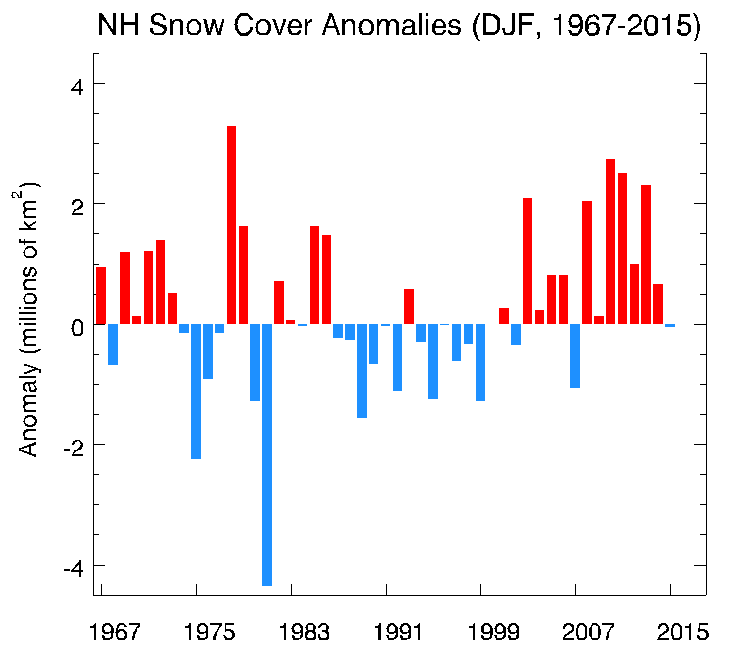
Figure 1: Snow cover extent anomaly (in millions of km2) for December-February in the Northern Hemisphere. Anomalies are computed relative to the 1981-2010 average. Data is taken from the NOAA snow chart Climate Data Records program.
Though winter SCE was above normal, positive temperature anomalies in Eurasia led to below average snow accumulation (depth) and cover throughout the spring. A record low SCE was set for April 2014, while March and May both saw snow cover extents among the six lowest since 1967. In summary, the spring of 2014 had the second lowest Eurasian SCE on record, with only 2009 receiving less snow.
2014 Seasonal Snow Depth Anomalies
Snow depth anomalies derived from the Canadian Meteorological Centre daily gridded snow depth analysis (Brasnett, 1999) show the seasonal development of terrestrial, hemispheric snow depth from December 2013 to November 2014 (Figure 2). Negative snow depth anomalies in Europe and Russia were contrasted by positive anomalies over Siberia and eastern North America, consistent with regional SCE totals. Above average Eurasian surface temperatures in winter and spring also corresponded to decreased snow depth across Russia and Northern Europe. The magnitude of these surface temperature anomalies weakened from June to August, and very few regions of anomalous snow depth persisted through the summer. Late fall and early winter 2014 saw isolated regions of slightly increased snow depth in Siberia and the northern Canada.
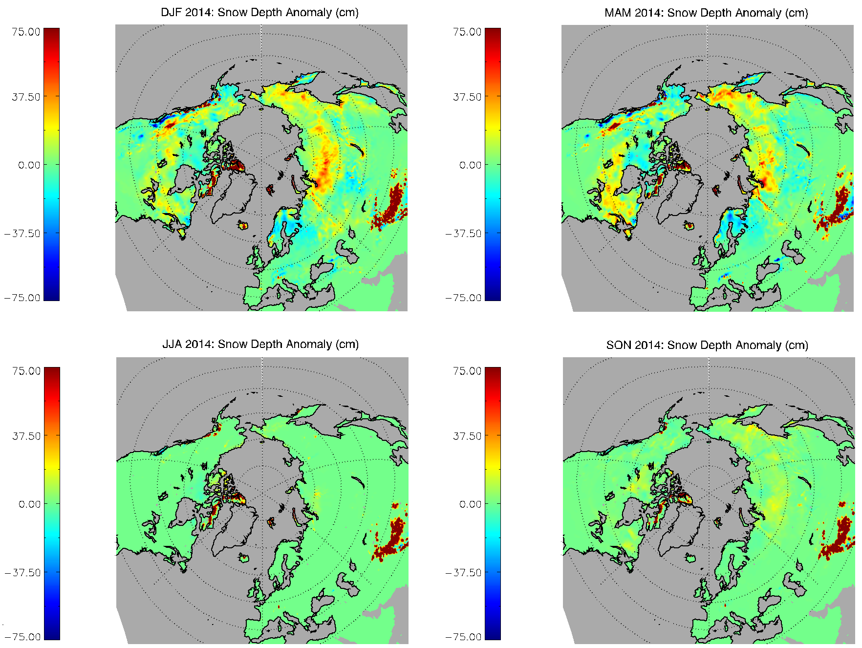
Figure 2: Mean 2014 seasonal snow depth anomaly (in cm) for the Northern Hemisphere. Extensive depth increases in eastern North America and Siberia outweighed negative anomalies in Eurasia and western North America. Greenland and marine snow depth anomalies were screened out at the suggestion of the data provider. Data from NSIDC.
Snow Extent and Arctic Sea Ice
Feedback cycles between multiple aspects of the cryosphere are numerous, and can have dramatic implications for global climate change. While terrestrial snow cover and sea ice extent are not explicitly interconnected, the rates of change between these two fundamental indicators of the cryospheric state are similar (Figure 3). Since the beginning of the satellite record, the decreases in the annual minimum extents of snow and ice extent in June and September indicates that snow reacts similarly to, and perhaps even more strongly than, sea ice to a warming Arctic. Inter-annual variability in June snow cover is greater than September sea ice extent, but the five-year running means indicate a loss of summer snow and sea ice over the last three decades.
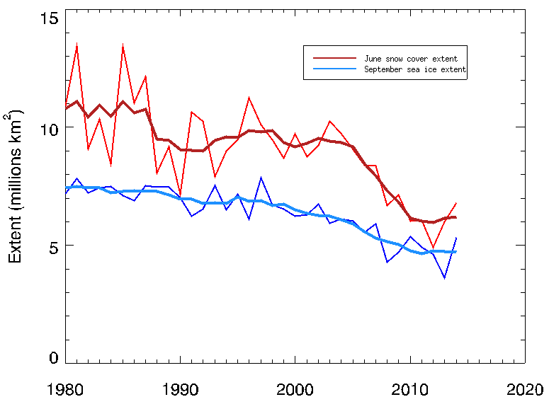
Figure 3: Northern Hemisphere June SCE plotted with September Arctic sea ice extent, 1980-2014. Darker red and blue lines are the respective 5-year running means of the snow and ice extent record. Data from NOAA snow chart CDR program and NSIDC. After Derksen et al. (2015).
For additional information on Northern Hemisphere snow extent in 2014, see Derksen et al. (2015) and Robinson (2015).
Southern Hemispheric Snow Coverage
The lack of land area at high latitudes in the Southern Hemisphere (SH) means that the region experiences substantially less terrestrial snowfall than the Northern Hemisphere. Measurable snow accumulation, then, occurs in the high elevations of the Andes Mountains in South America or the Antarctic continent, where glaciers are also present. Using current satellite technology it is very difficult to distinguish snow cover from glacial ice, and therefore long-term datasets of SH snow cover are less common.
Figure 4 shows snow cover over South America for 2014. The 2014 autumn (March-May) saw abnormal snow cover (blue) in Peru, Ecuador, and northern Chile. This spatial pattern of snow cover (blue) usually follows the north-south axis of the Andes Mountains, southward from Ecuador and Peru down the Chile-Argentina border. Snow cover typically moves eastward into Patagonia from the southern Andes Mountains from June-August, and this feature was pronounced in 2014.
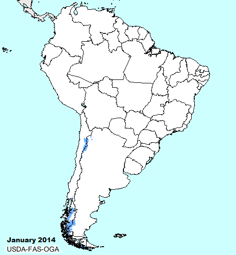
Figure 4: Anomalous snow cover (in blue) for 2014 in 10-day periods. Coverage anomalies are based on the 35-year average from 1966-2001. Data are from USDA.
References
Armstrong, R.L. and M.J. Brodzik. 2002. Northern Hemisphere EASE-Grid Weekly Snow Cover and Sea Ice Extent Version 2. Boulder, CO, USA: National Snow and Ice Data Center.
Brown, Ross D. and Bruce Brasnett. 2010, updated annually. Canadian Meteorological Centre (CMC) Daily Snow Depth Analysis Data. © Environment Canada, 2010. Boulder, Colorado USA: National Snow and Ice Data Center.
Derksen, C., and R. Brown, 2013: Arctic – Terrestrial Snow [in “State of the Climate in 2012”]. Special Supplement, Bull. Amer. Meteor. Soc., 94(8), August 2013, S132-S133.
Derksen, C., R. Brown, L. Mudryk, and K. Luojus, 2015: Arctic – Terrestrial Snow. [in "State of the Climate in 2014"]. Bull. Amer. Meteor. Soc., 96(7), July 2015, S133-S135. (http://www.arctic.noaa.gov/reportcard/snow_cover.html)
Robinson, D.A., 2015: Northern Hemisphere Snow Cover [in “State of the Climate in 2014”]. Special Supplement, Bull. Amer. Meteor. Soc., 96(7), July 2015, S18-S19. (http://climate.rutgers.edu/snowcover/files/Robinson_snowdata2014.pdf)
