 |
Metadata
|
 |
Davos
Integrated CryoNet Cluster Information
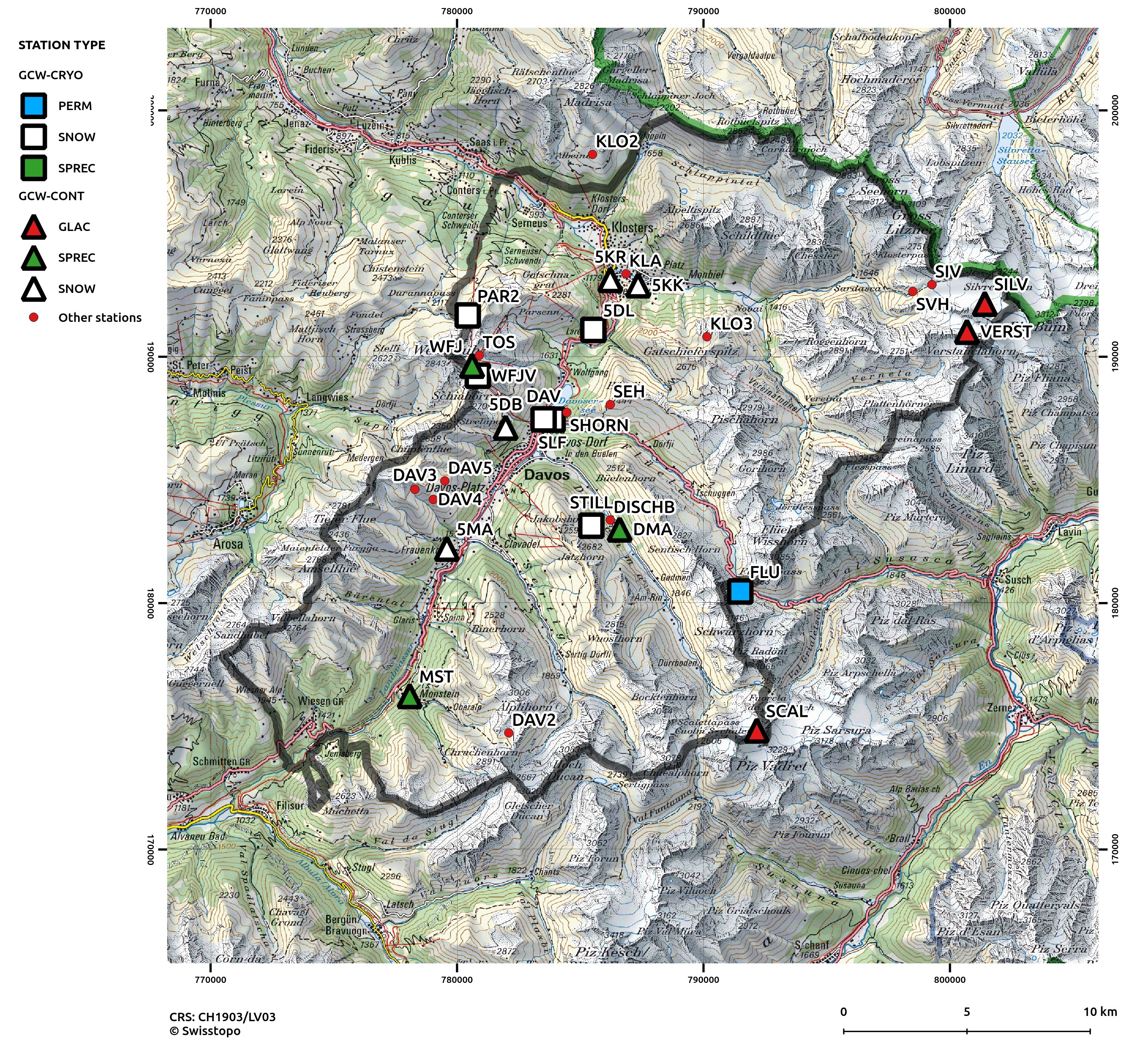
Stations in This Site
This site is comprised of the following stations:
- Fluela permafrost station (FLU) - CryoNet Station
- Weissfluhjoch Versuchsfeld (WFJV) - CryoNet Station
- Weissfluhjoch SwissMetNet AWS (WFJ) - Contributing Station
- Davos SLF (SLF) - CryoNet Station
- Bueschalp observer station (5DB) - Contributing Station
- Stillberg station (STILL) - CryoNet Station
- Silvretta Glacier (SILV) - Contributing Station
- Davos SwissMetNet AWS (DAV) - CryoNet Station
- IMIS Parsenn 2 automatic station (PAR2) - CryoNet Station
- Matta Frauenkirch observer station (5MA) - Contributing Station
- Klosters RhB observer station (5KR) - Contributing Station
- Klosters Kraftwerk observer station (5KK) - Contributing Station
- NIME station Dischma (DMA) - Contributing Station
- NIME station Monstein (MST) - Contributing Station
- Scaletta Glacier (SCAL) - Contributing Station
- Verstancla Glacier (VERST) - Contributing Station
- Davos Laret (LAR) - CryoNet Station
- Dischma Chaiseren (DMAC) - CryoNet Station
- Dischma Dürrboden (DMAD) - CryoNet Station
Broad Research Focus
The WSL Institute for Snow and Avalanche Research SLF covers many aspects of snow research, that is, snow physics, snow avalanche formation and dynamics, snow hydrology and climatology, snow-atmosphere and snow-vegetation interactions, drifting and blowing snow, avalanche hazard mitigation (forecasting and permanent structures). Alpine permafrost is also a major topic of research at SLF. Accordingly, research at SLF covers two components of the cryosphere while our partners GLAMOS and MeteoSwiss add the components Glacier and Solid precipitation.
Most of the studies are field based and thus SLF relies on a large number of fixed and mobile research sites. The former are the stations contributing to the CryoNet site while temporary stations often form the latter. In addition, basic snow physics research is conducted within onsite cold laboratories and wind tunnel. It is this broad range of research fields combined with the availability of long- and short term records that make Weissfluhjoch-Davos a unique CryoNet integrated site.
Integrated Approach
The cryosphere (4 components), the hydrosphere, the atmosphere (radiation and pollution), and the biosphere (forest and plant ecology) are all in the primary research focus of this renowned research institute. In addition, collaboration between the partners listed in the partner section below is already well established and ongoing.
The wealth of meteorological stations, long- and short term, allow studies of the effects of elevation gradients and various micro-climates found within the borders of the site.
With the recent installation of the MeteoSwiss operational Weather Radar on top of Weissfluh, new research topics will open up. Furthermore, the planned Swiss Alpine Remote Sensing Site within the borders of the CryoNet site provides a long expected site for cal/val activities in collaboration with space agencies.
Representativeness of the Cluster
Even though snow depth cannot be easily extrapolated from a point measurement to the surroundings, the long-term record of Weissfluhjoch Versuchsfeld has been shown to represent quite well general annual snow depth trends over the Swiss Alps (Marty and Meister, 2012). Contrary to this representativeness, one of the emerging characteristic of the Weissfluhjoch-Davos integrated site is its heterogeneity in terms of precipitation regimes (micro-climates) and the diversity of research topics addressed within its borders. It also represents a dynamic community located in a mid-Alpine environment that will face substantial challenges due to climate changes, including natural hazards directly affecting the city of Davos.
Cluster Facilities
Fully-fledged research facility located in Davos (offices, machine & electronic shops, IT-services, etc.). Easy accessibility to some sites (cable cars, roads), mountaineering skills required in winter.
Other Networks to Which This CryoNet Cluster Belongs
- Cryosphere: BEOB, PERMOS, GLAMOS, IMIS, SwissMetNet, MeteoSwiss Weather Radar Network
- Other components of the earth system: GAW, LWF Swiss Fluxnet, NABEL, HUG
- See partner section for more info on acronyms
Measurement Methods Used
- WMO Technical Regulations
- GTN-P
- GTN-G/WGMS
Other relevant measurement method documents:
SLF-Beobachterhandbuch: Vergleichsstationen
International Classification for Seasonal Snow on the Ground
Data Information
- Are the data quality controlled? yes
- How are the data accessible? an existing data center
- Data availability (may depend on the variable measured): in real-time, in near real-time, delayed less than one year
Publications
Marty, C. and R. Meister. 2012. Long-term snow and weather observations at Weissfluhjoch and its relation to other high-altitude observatories in the Alps. Theor. Appl. Climatol., 110(4), 573-583. doi:10.1007/s00704-012-0584-3
Additional Information Documents
Measurements
The measurements made at Davos are listed in the following tables. This is a combination of measurements made at the stations within the site, where the start and end years in the tables are the earliest and latest years of measurement. (Note: If End Year is blank, measurements are ongoing.)
Cryosphere Measurements
| Atmosphere Measurements
|
Measurement Notes and Other Measurements
| Category | Description or List |
|---|---|
| Snow | Ground surface temperature. Lysimeter (5 m^2) start 1992; snow pillow start 2005; weighing gauge start 20yy; . Snow depth and depth of snowfall are both measured and provided by the WSL Institute for Snow and Avalanche Research SLF Davos (see station Weissfluhjoch Versuchsfeld (WFJV)) Water equivalent of snowfall measured only if depth of snowfall > 10 cm Automatic measurement of snow depth starting 1997. Bi-weekly winter operation. Snow depth measured perpendicular to slope (36°, north-east-facing) Snow depth was measured daily at this location since 1931. Full length record by merging with data from contributing station 5KR. Depth of fresh snow during the last 24 hours in cm (Depth of snowfall HN) Depth of fresh snow during the last 24 hours in cm (Depth of snowfall HN) Sustainability of measurements not guaranteed. Snow depth measured with Laser sensor. |
| Seasonally frozen ground | measurements at depths of 10, 30, and 50 cm. - Soil temperature 0, 10, 50, 100 cm depth. Soil temperatures and heat flux. |
| Glacier | Front variation (from observations) 1956 - , continuous Above, "Ice thickness" should be "Ice thickness change" and "sporadic" should be "periodic" Front variation (from observations) 1895 - 2012, periodic Above, "Ice thickness" should be "Ice thickness change" and "sporadic" should be "periodic" Front variation (from observations) 1926 - 2015, continuous Above, "Ice thickness" should be "Ice thickness change" and "sporadic" should be "periodic" |
| Atmosphere | Starting December 2015, the fifth Radar of MeteoSwiss located on top of Weissfluh (46.83496, 9.79444; 2833 m) will allow for detailed insight in precipitations above the region of this CryoNet Site. Station FLU2 of IMIS network. Total precipitation: daily values from 1974 - 1982, not digitalized. Precipitation is measured on Weissfluhjoch Versuchsfeld (2536 m asl), height adjustable gauge kept 1.5 to 2 m above snow / ground. Daily measurements available for the period 1974-1982. Most of the precipitation falls as solid precipitation. A Pitot-tube anemometer as well as instruments measuring incoming short and downwelling long-wave radiation are also installed on the wind mast (property of WSL Institute for Snow and Avalanche Research SLF) The fifth weather radar Weissfluhgipfel of the Swiss Weather Radar Network, located on top of Weissfluh, 2840 m above sea level commenced operation in December 2016 https://oscar.wmo.int/OSCAR/index.html#/search/station/stationReportDetails/2365. - Air temperature 1, 0.5, and 0.1 m - Dew point - ozone - Shortwave normal (perpendicular) to slope. - Air temperature @ 5 cm - Surface temperature - Soil temperatures (-5, -10, -20 cm) - Radioactivity. Unheated rain gauge. Type and intensity of precipitation at observation time Degree of cloud cover at observation time. Type and intensity of precipitation at observation time Degree of cloud cover at observation time. Disdrometer, ultrasonic anemometer, etc. will be added during the 2018 Winter. |
| Hydrology | Snow hydrology (http://www.slf.ch/ueber/organisation/gebirgshydrologie/schnee_hydro/index_EN) |
| Ecology | Mountain ecosystems (http://www.slf.ch/ueber/organisation/oekologie/gebirgsoekosysteme/projekte/baeume_waldgrenze/index_EN) Tree growth study site. |

A variety of measurement and research sites are located within the region of the site. There are numerous different measurements relevant to the cryosphere, for example, permafrost temperature, active layer depth, albedo, snow surface temperature, which have been measured over several decades and will continue to be monitored in future.
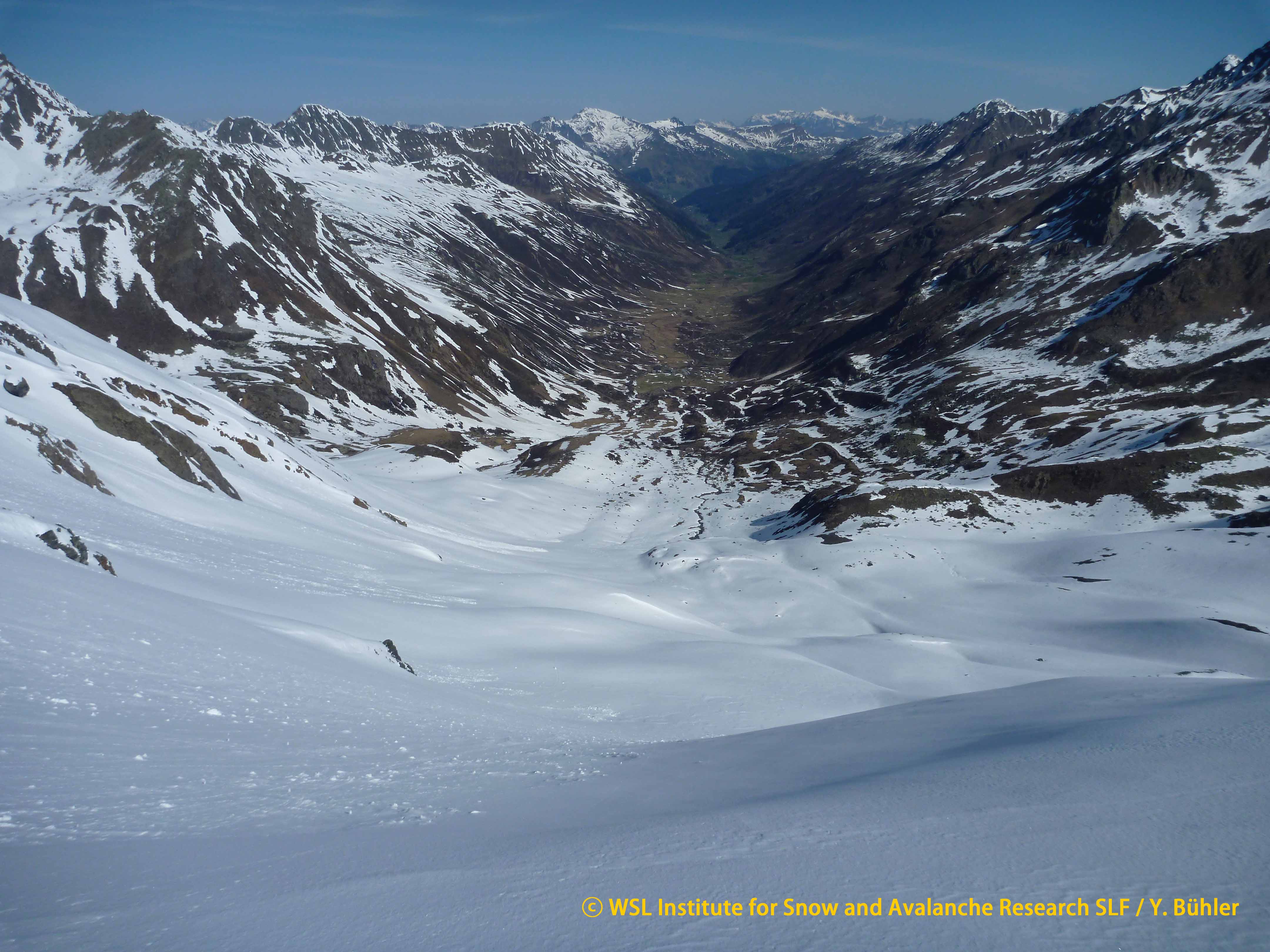
Long-term measurements of temperature, precipitation and snow are available since the end of the 19th century in Davos as well as the longest continuous series of daily snow measurements at high elevation (Weissfluhjoch Versuchsfeld, 2536 m asl). The site also encompasses the Silvretta glacier at roughly 3000 m asl with the second-longest mass-balance series worldwide (Huss et al., 2015). It is one of the reference glaciers of the World Glacier Monitoring service (WGMS). In addition, the Dischma valley, well known from a large number of studies on snow hydrology, snow-vegetation interactions (Stillberg), and on accumulation and ablation patterns, lies within the site.
Finally, a newly installed weather radar (MeteoSwiss) on top of Weissfluh (46.83495N, 9.79446E, 2832 m asl) and a planned Swiss Alpine Remote Sensing station (46.84506N, 9.87143E, 1513 m asl) will allow for new fields of research, additional monitoring, and cal/val activities.
A list of CryoNet, GCW contributing, and other stations within the site is available under Additional Information Documents below (document 1)
Interactive map available here: http://bit.ly/1qEgXRJ