 |
Metadata
|
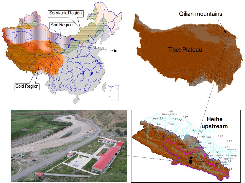 |
Qilian
Primary CryoNet Station Information
Other Networks to Which This CryoNet Station Belongs
- CAS-LASON(The Land surface process observation network)
Measurement Methods Used
- WMO Technical Regulations
Other relevant measurement method documents:
Goodison B.E., P.Y.T. Louie, D. Yang, 1998, WMO Solid Precipitation Measurement Intercomparison- Final Report, WMO/TD - No. 872.
Data Information
- Are the data quality controlled? yes
- How are the data accessible? HTTP (web), an existing data center
- Data availability (may depend on the variable measured): delayed more than one year
Publications
Chen R S, Song Y X, Kang E S, et al. A Cryosphere-Hydrology Observation System in a Small Alpine Watershed in the Qilian Mountains of China and Its Meteorological Gradient. Arctic, Antarctic, and Alpine Research, 2014, 46(2): 505-523.
Chen R, Liu J, Song Y. Precipitation type estimation and validation in China. Journal of Mountain Science, 2014, 11(4): 917-925.
Yang Yong, Chen Rensheng, Han Chuntan, et al. Measurement and estimation of the summertime daily evapotranspiration on alpine meadow in the Qilian Mountains, Northwest China. Environmental Earth Sciences, 2013, 68: 2253-2261.
Zongxing L, Qi F, Wei L, et al. Study on the Contribution from Cryosphere to Runoff in the Cold Alpine Basin: A Case Study of Hulugou River Basin in the Qilian Mountains. Global and Planetary Change, 2014.
Liu J, Chen R, Wang G. Snowline and snow cover monitoring at high spatial resolution in a mountainous river basin based on a time-lapse camera at a daily scale. Journal of Mountain Science, 2015, 12(1): 60-69.
Liu J, Chen R, Song Y X, et al. Observations of precipitation type using a time-lapse camera in a mountainous region and calculation of the rain/snow proportion based on the critical air temperature. Environmental Earth Sciences, 2015, 73(4): 1545-1554.
Liu Z, Chen R, Song Y, et al. Estimation of aboveground biomass for alpine shrubs in the upper reaches of the Heihe River Basin, Northwestern China. Environmental Earth Sciences, 2015, 73(9): 5513-5521.
Zhangwen Liu, Rensheng Chen, Yaoxuan Song, Chuntan Han. Aboveground biomass and water storage allocation in alpine willow shrubs in the Qilian mountains in China. Journal of Mountain Science. 2015, 12(1): 207-217.
Zhangwen Liu, Rensheng Chen, Yaoxuan Song, Chuntan Han. Distribution and estimation of aboveground biomass of alpine shrubs along an altitudinal gradient in a small watershed of the Qilian Mountains, China. Journal of Mountain Science, 2015, 12(4): 961-971. DOI 10.1007/s11629-013-2584-7,.
Additional Information Documents
Measurements
The measurements made at Qilian are listed in the following tables. (Note: If End Year is blank, measurements are ongoing.)
Cryosphere Measurements
| Atmosphere Measurements
|
Measurement Notes and Other Measurements
| Category | Description or List |
|---|---|
| Snow | On the sub-watershed and small watershed scales, terrestrial photographic methods have been used to record changes in snow area every four hours (automatically) since March 2010. |
| Permafrost | Permafrost (above 3700m) and seasonal frozen soil are both found in the Hulu watershed. The permafrost area is so difficult to climb that there are no deep soil temperature bores at present. Only the active layer and seasonal frozen soil are currently monitored. Multilayer soil moisture and temperature are measured in all five automatic meteorological towers. The soil profile in station no.1-3 and 5 is about 1.6~2.0m, while in station no.4 it is 3.0m. In addition to these weather requirements, the five stations have been specially installed on five different underlying surfaces to enable discussion of the water and heat transfer processes in the frozen soil-vegetation-atmosphere-transfer system (SVATs). Station no.2 and 3 lies in the permafrost area with active layer depths of 3.5m and 2.4m, respectively. The maximum freezing depths in the regions where station no.1, 4 and 5 are located are about 1.3m (sunny slope, 3382m), 2.7m (flat area, 3232m) and 2.4m (flat area, 2980m), respectively. Furthermore, in the two meteorological fields, the soil temperature in superficial layers (<=45cm) is measured manually. Freezing depth (<3.0m) is also measured in the standard meteorological field. Considering the land surface temperature is measured only in flat bare soil at routine stations in China, a total of 24 recorders (TidbiT v2, Onset, USA) have been fixed at locations with different azimuth, slope and vegetation types at similar elevations. By combining the data these recorders gather with solar elevation and air temperature readings, etc., an empirical formula on land surfaces temperature may be created for cryospheric sciences and other subjects. |
| Glacier | The Hulu watershed has a total of 6 glaciers, the combined area of which has fallen from 1.45km2 in 1956 (Wang, 1981) to 1.01km2 in 2010 (using Global Positioning System Real Time Kinematic (RTK-GPS), 2010). Among the 6 glaciers, one has disappeared and one has separated into 2 glaciers. The largest one, Shiyi Glacier, has shrunk in area from 0.64km2 to 0.54km2 and has a glacier terminus that has risen from 4270m to 4320m in the past 55 years (1956~2010). Ground-penetrating radar data indicate the maximum depth of Shiyi Glacier was about 70m in October 2010. Shiyi Glacier was chosen for monitoring because its type (a combination of valley glacier and hanging glacier) and the area are close to those typical of the Qilian Mountains (most glaciers are hanging or valley glaciers with a mean area of about 0.33km2). A total of 6 stakes and 2 totalizer were installed in Shiyi Glacier in July 2009, with 15 stakes and 1 glacier temperature bore being added in October 2010. Because of the appearance of several moraines, the glacier runoff is sometimes roughly estimated by using isotopes instead of measuring it directly. A simple automatic station with an one-layer wind, air temperature, humidity and weighted rainfall recorder is installed in the glacier in July 2012. Several CCD cameras with storage cards are also being installed to monitor the matter balance according to the gage changes in the stakes. |
| Atmosphere | Meteorology especially the precipitation is very limited in the Alpine regions in China. The small watershed at Hulu has a total of 5 automatic meteorological towers and two meteorological parks. One of the meteorological parks was designed as a national standard field, while the other has a more straightforward design. In the standard field, at all stations other than automatic station no.5, atmospheric pressure, air temperature (maximum, minimum and routine), relative humidity, sunshine hours, evaporation (20cm), soil temperature (surface and superficial layer), frozen soil depth and weather phenomena have been observed manually since June 2009. In addition, two mini-lysimeters (31.5cm, h=40cm) are used to measure evapotranspiration on alpine grasslands twice a day. To reduce measurement error, readings from five rain gauges are contrasted in making rainfall and snowfall observations. One is the China standard recorder (20cm, h=70cm) used in all routine stations in China; the second is also the routine model, but with a windshield (Alter windshield); the third and fourth are pit gauges with different caliber sizes (20cm and A500; Goodisonet al., 1998) and the last one is the Double-Fence International Reference (DFIR). In the simple field, a siphon rainfall recorder, an evaporating dish, one T-200B series precipitation gauge (Geonor) and four mini-lysimeters were set up in October 2011 in all stations other than automatic station no.4. To detect the complexities of alpine precipitation, total 14 totalizers and two weighted rainfall recorders (self made; with a one-layer wind, air temperature and relative humidity) have also been installed over the small watershed (2960m-4650m) in June, 2009 and in July, 2012, respectively. Now for the precipitation, there are total 7 automatic weighted rainfall recorders, one tipping-bucket rain gauge, one siphon rainfall recorder, two Chinese standard recorders and 14 totalizers in the Hulu watershed. Data used here except from the totalizers are roughly calibrated by the pit gauges (A500). The more detailed calibration would wait for the DFIR data. |
| Hydrology | Runoff is now measured both manually and automatically in three sections. One is located in the discharge zone of Hulu watershed, whereas the other two lie in alpine desert and meadow sub-watersheds. The weirs are well-designed and built. Flow velocity and water level are measured manually, with readings decreasing from every two hours in June 2009 to three times per day now. Two HOBO sensors (Onset, USA) have been installed in the lentic wells to record the water level in each section. A CCD camera with a storage card is set up to complement these sensors in June 2012 and obtain more accurate water level data. |
| Ecology | Basic soil and vegetation data are regularly gathered in the Hulu watershed. Though land use data and vegetation types are respectively acquired from Advanced Land Observing Satellite (ALOS, 2.5m) images and field investigations, they are somewhat raw. We hope to obtain more detailed data in the second Hi-WATER experiment conducted in August 2012. |
| Other | We also have Lysimeters observation of evapotranspiration, sap flow measurement system. |

In spatial terms, the field experiments could be classified into four types: point, slope, sub-watershed and small watershed. The point scale experiments are distributed over the Hulu watershed and involve various scientific subjects. Three slope scale experiments are being conducted: each involves using the runoff field to contrast shrubs with meadow, glacier and forest water balance fields. Two sub-watersheds with hydrological sections and meteorological variables, soil water content and temperature and ecological quadrats, etc., were specifically chosen for alpine desert and alpine meadow, because these two underlying surfaces cover about 22% and 52% of the upstream area of the Heihe mainstream basin, respectively.
By subject, the field experiments focus on the cryosphere, ecology, meteorology and hydrology, and could be roughly classified as cryospheric hydrology.