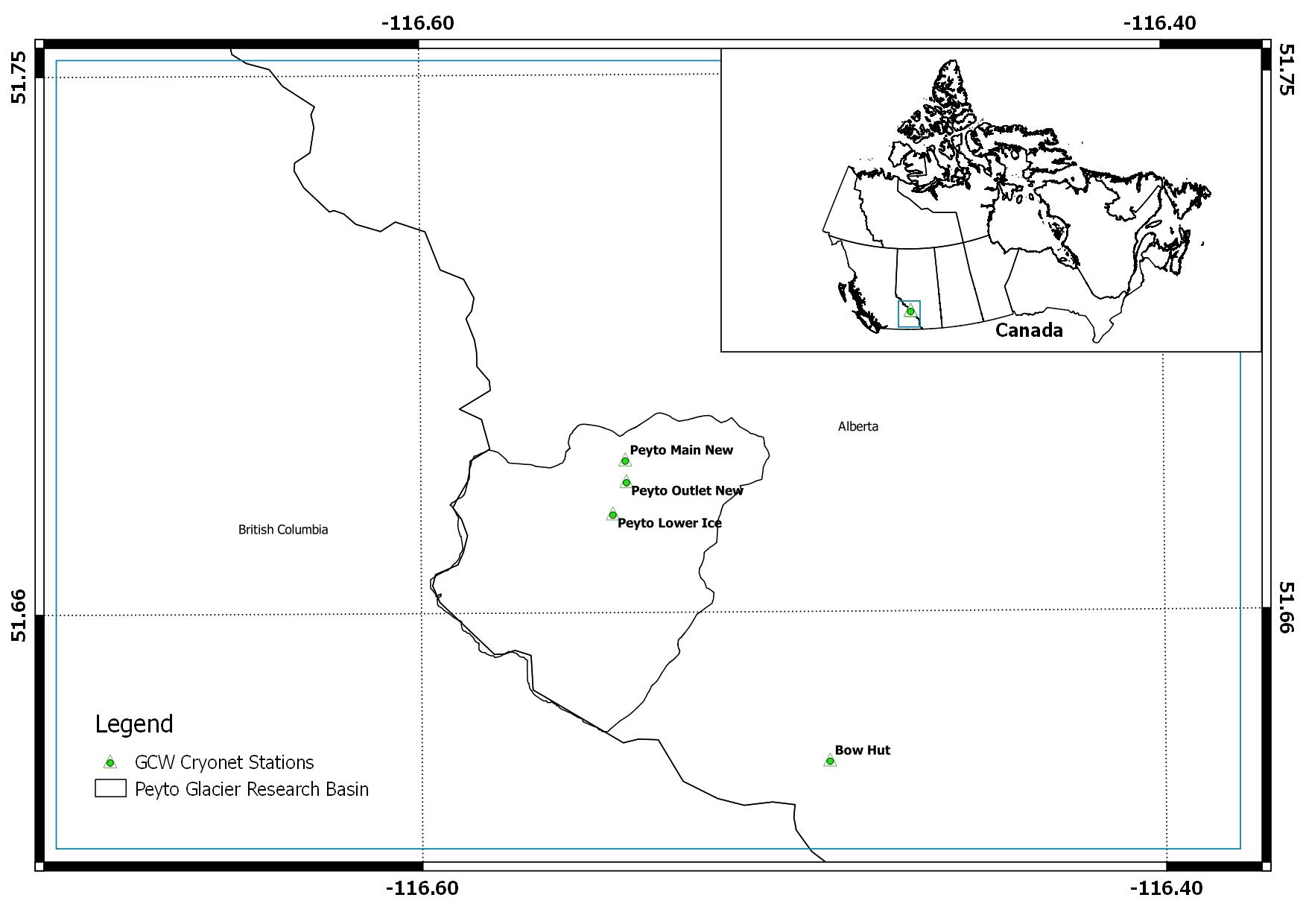
Peyto Glacier in Banff National Park is a valley outflow glacier Wapta Icefield in the Waputik Mountains, a part of the Canadian Rocky Mountains – the headwaters of major river systems in western Canada [location map is included]. During the 1960s, the area of the glacier was 13.4 km2. However, it has been continuously losing mass since the mid-1970s (9.9 km2 of the glacier as of 2016) and the new proglacial lake formed at the tongue of the glacier is increasing in size every year. The lake in the research basin has been named as ‘Lake Munro’ by the Centre for Hydrology (University of Saskatchewan) to honor Scott Munro’s research contribution to the glacier. Peyto Creek flowing out of Lake Munro drains the Peyto Glacier Research Basin (22.4 km²) and discharges to Peyto Lake, which has outflow into the Mistaya River, one of the tributaries of the North Saskatchewan River.
Although the first record of Peyto Glacier goes back to the photograph in 1896 by Walter D. Wilcox, significant research of the glacier began in 1965, when it was selected as one of the research sites for the International Hydrological Decade (IHD). The past studies over the glacier is well documented in the book – ‘Peyto Glacier: One Century of Science’ edited by Demuth et al., (2006). Automatic weather stations (AWS) were installed on the ice and off-glacier sites and several post-IHD-period micrometeorological studies were made by Dr. Scott Munro, University of Toronto. These climate stations are now being continued by the Centre for Hydrology – University of Saskatchewan.
Other Networks to Which This CryoNet Station Belongs
Canadian Rockies Hydrological Observatory (CRHO)
Changing Cold Regions Network (CCRN)
Water, Ecosystem, Cryosphere and Climate (WECC) Observatories
Global Water Futures (GWF)
Data Information
Are the data quality controlled? yes
How are the data accessible? HTTP (web), other
Data availability (may depend on the variable measured): in near real-time, delayed less than one month, delayed less than one year
Publications
Changing Cold Regions Network, 3. Wapta Icefield/Peyto Glacier, AB. http://ccrnetwork.ca/science/WECC/western-cordillera/peyto-glacier.php
Measurements
The measurements made at Peyto Main are listed in the following tables. (Note: If End Year is blank, measurements are ongoing.)
Cryosphere Measurements
Element
Variable
Start Year
End Year
Frequency
Snow
Snow on the ground (WMO code 0957)
1965
Continuous
Snow
Depth
1965
Continuous
Snow
Snow water equivalent
2013
Sporadic
Snow
Snowpack profile
2013
Continuous
Snow
Snowfall depth
1991
Continuous
Snow
Water equivalent of snowfall
2013
Continuous
Snow
Albedo
2013
Continuous
Snow
Temperature
1991
Continuous
Atmosphere Measurements
Element
Variable
Start Year
End Year
Frequency
Met
Air temperature
1991
Continuous
Met
Humidity/vapour pressure
1991
Continuous
Met
Wind speed and direction
1991
Continuous
Met
Air pressure
1991
Continuous
Met
Snowfall
1991
Continuous
Met
Total precipitation
1991
Continuous
Met
Rainfall
1991
Continuous
Radiation
Downwelling shortwave
1991
Continuous
Radiation
Upwelling shortwave
2013
Continuous
Radiation
Downwelling longwave
2006
Continuous
Radiation
Upwelling longwave
2013
Continuous
Radiation
Sunshine duration
1965
1974
Sporadic
Measurement Notes and Other Measurements
Category
Description or List
Atmosphere
The precipitation was not reliable in winter until recently.
Other
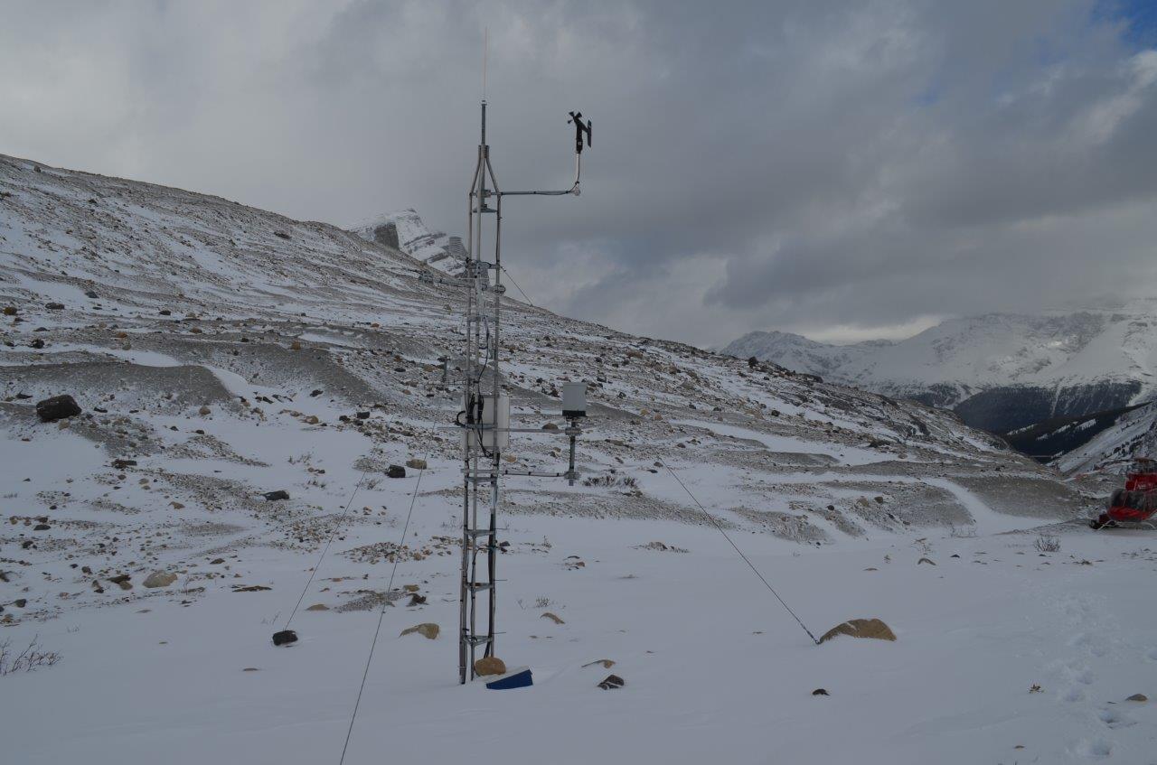
The Peyto Main (also known as 'Peyto Creek Base Station') was operational during summer months in IHD period. It was re-established during the 1980s with data loggers. New instruments with a new setting have also been added in 2013 by Centre for Hydrology, University of Saskatchewan.

Although the first record of Peyto Glacier goes back to the photograph in 1896 by Walter D. Wilcox, significant research of the glacier began in 1965, when it was selected as one of the research sites for the International Hydrological Decade (IHD). The past studies over the glacier is well documented in the book – ‘Peyto Glacier: One Century of Science’ edited by Demuth et al., (2006). Automatic weather stations (AWS) were installed on the ice and off-glacier sites and several post-IHD-period micrometeorological studies were made by Dr. Scott Munro, University of Toronto. These climate stations are now being continued by the Centre for Hydrology – University of Saskatchewan.