 |
Metadata
|
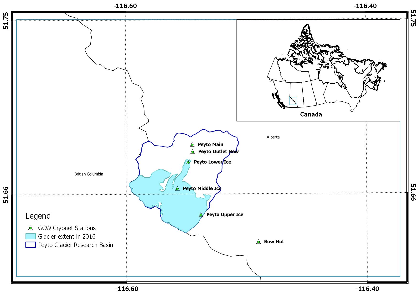 |
Peyto Glacier [Candidate]
Integrated CryoNet Cluster Information
Stations in This Site
This site is comprised of the following stations:
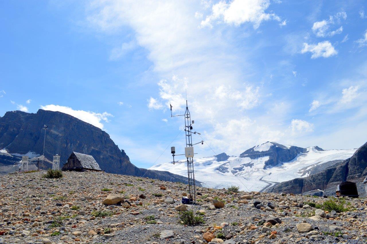
- Peyto Main - CryoNet Station
- Peyto Lower Ice - CryoNet Station
- Bow Hut - CryoNet Station
- Peyto Outlet New - CryoNet Station
Broad Research Focus
The research focus of the cluster is to improve understanding of snow and glacier ablation and accumulation dynamics and how this influences high mountain hydrology and to improve hydrological modeling capacity in high mountain cold regions.
Integrated Approach
Energy and mass balance studies both ice-covered and ice-free areas within the study basin.
Representativeness of the Cluster
Alpine glaciers in the Canadian Rockies
Cluster Facilities
Meteorological and Hydrological measurements supported by snow surveys and glacier mass balance studies.
Other Networks to Which This CryoNet Cluster Belongs
- Canadian Rockies Hydrological Observatory (CRHO)
- Changing Cold Regions Network (CCRN)
- Water, Ecosystem, Cryosphere and Climate (WECC) Observatories
- Global Water Futures (GWF)
Data Information
- Are the data quality controlled? yes
- How are the data accessible? HTTP (web), other
- Data availability (may depend on the variable measured): in near real-time, delayed less than one month, delayed less than one year
Publications
DeBeer, C.M., Wheater, H.S., Carey, S.K., Chun, K.P., 2015. Recent climatic, cryospheric, and hydrological changes over the interior of western Canada: a synthesis and review. Hydrol. Earth Syst. Sci. Discuss. 12, 8615–8674. doi:10.5194/hessd-12-8615-2015
Debeer, C.M., Wheater, H.S., Quinton, W.L., Carey, S.K., Stewart, R.E., MacKay, M.D., Marsh, P., 2014. The Changing Cold Regions Network: Observation, diagnosis and prediction of environmental change in the Saskatchewan and Mackenzie River Basins, Canada. Sci. China Earth Sci. 58, 46–60. doi:10.1007/s11430-014-5001-6
Demuth, M.N., Keller, R., 2006. An assessment of the mass balance of Peyto glacier (1966-1995) and its relation to Recent and past-century climatic variability, in: Demuth, M.N., D.S.M. and G.J.Y. (Ed.), Peyto Glacier: One Century of Science. National Hydrology Research Institute, Saskatoon, Saskatchewan, pp. 83–132.
Demuth, M.N., Munro, D.S., Young, G.J. (Eds.), 2006. Peyto Glacier: one century of science. Environment Canada.
Demuth, M.N., Pietroniro, a, 2003. The impact of climate change on the glaciers of the Canadian Rocky Mountain eastern slopes and implications for water resource-related adaptation in the Canadian prairies “Phase I ” - Headwaters of the North Saskatchewan River Basin. Holocene 4322, 96.
Demuth, M.N., Sekerka, J., Bertollo, S., 2009. Glacier mass balance observations for Peyto Glacier, Alberta, Canada (updated to 2007), Spatially Referenced Data Set Contribution to the National Glacier-Climate Observing System, State and Evolution of Canada’s Glaciers.
Dyurgerov, M., Mark, E., Instaar, M., Nsidc, R.A., 2002. Glacier Mass Balance and Regime?: Data of Measurements and Analysis Occasional Paper No . 55 Institute of Arctic and Alpine Research , University of Colorado Glacier Mass Balance and Regime?: Data of Measurements and Analysis ISSN 0069-6145. Occas. Pap. No 55 268.
Goodison, B., 1972. An Analysis of Climate and Runoff Events for Peyto Glacier, Alberta, Inland Waters Directorate, Scientific Series No. 21. Environment Canada, Ottawa, Canada.
Kehrl, L.M., Hawley, R.L., Osterberg, E.C., Winski, D. a., Lee, A.P., 2014. Volume loss from lower Peyto Glacier, Alberta, Canada, between 1966 and 2010. J. Glaciol. 60, 51–56. doi:10.3189/2014JoG13J039
Munro, D.S., 2011. Peyto Creek hydrometeorological database (Peyto Creek Base Camp AWS) [WWW Document]. IP3 Arch. URL www.usask.ca/ip3/data
Munro, D.S., 2007. Creating a Runoff Record for an Ungauged Basin: Peyto Glacier, 2002-2007, in: Pomeroy, J.W., Spence, C., Whitfield, P.H. (Eds.), Putting Prediction in Ungauged Basins into Practice. Canadian Water Resources Association, pp. 2002–2007.
Ommanney, C.S.L., 1987. Peyto Glacier: A Compendium of Information Prepared for Parks Canada. Saskatoon, Saskatchewan, S7N 3H5.
Sandford, R.W., 2012. Cold Matters: The State and Fate o Canada’s Fresh Water. Rocky Mountain Books Ltd, Victoria [B.C.].
WGMS, 2017. Fluctuations of Glaciers Database [WWW Document]. World Glacier Monit. Serv. Zurich, Switz. doi:10.5904/wgms-fog-2017-06
Young, G.J., 1977. The seasonal and diurnal regime of a glacier-fed stream - Peyto Glacier Alberta.pdf.
Young, G.J., Stanley, A.D., 1976. Canadian Glaciers in the International Hydrological Decade Program, 1965-1974 No. 4. Peyto Glacier, Alberta - Summary of measurements.
Measurements
The measurements made at Peyto Glacier are listed in the following tables. This is a combination of measurements made at the stations within the site, where the start and end years in the tables are the earliest and latest years of measurement. (Note: If End Year is blank, measurements are ongoing.)
Cryosphere Measurements
| Atmosphere Measurements
|
Measurement Notes and Other Measurements
| Category | Description or List |
|---|---|
| Snow | Measurement data earlier than 2007 are also available for few of the stations in the Cluster. It is the AWS in the ablation zone of Peyto Glacier. It was first established by Dr. Scott Munro earlier than 2002. Centre for Hydrology continued it replacing the old station by the new instruments and setting in 2016. |
| Glacier | 1. Geodeolite mass balance measurements, using ablation stakes and snow pits, have been performed continuously since the IHD period. Mass balance data for 11 elevation bands were published (with a data gap for 1991-1992) in several publications (Demuth et al., 2009; Demuth & Keller, 2006; Dyurgerov, 2002; Ommanney, 1987; Young & Stanley, 1976). 2. The recent mass balance data are available from World Glacier Monitoring Service (WGMS, 2017). WGMS (http://www.wgms.ch) have compiled glaciological datasets [front variation, ELA and AAR, mass balance – winter, summer, and annual] from 1966 to present. |
| Atmosphere | The National Hydrology Research Institute (NHRI) paper titled ‘Peyto Glacier: A Compendium of Information Prepared for Parks Canada’ by Ommanney (1987) provides meteorological and mass balance data availability during the IHD and until 1984. It states that the meteorological station at the base camp took regular observations for temperature, humidity, precipitation, and cloud cover from 1965 to 1984 and for wind speed, sunshine hours, and incoming solar radiation from 1967 to 1984. Though these digital data are not available, a portion of these data (from 1965-1974) is available by abstraction from the published graphs (daily values) in the report prepared by Young and Stanley (1976). These climate observations at the base camp were made during the summer months for the meteorological variables of temperature, humidity, global radiation, sunshine duration, wind and precipitation. The details of these data and instruments used were documented in the publications by the Inland Waters Directorate of Environment Canada (Goodison, 1972; Young and Stanley, 1976). 2. Micro-meteorological Observation data are available at hourly intervals, from 1991 to date, from the Main Station. Some of these data (2002-2007) were published by the project - ‘Improving Processes & Parameterization for Prediction in Cold Regions Hydrology (IP3)’. The precipitation was not reliable in winter until recently. . 0. |
| Hydrology | 1. The observed daily outflow from the glacier at Peyto Creek is available for the period 1967 to 1977 from the Water Survey of Canada (http://www.ec.gc.ca/rhc-wsc/). 2. Stream gauging by sonic ranger has been continued by the Centre for Hydrology, University of Saskatchewan since 2013. 0. The observed daily outflow from the glacier at Peyto Creek is available for the period 1967 to 1977 from the Water Survey of Canada (http://www.ec.gc.ca/rhc-wsc/). Centre for Hydrology, University of Saskatchewan has resumed the flow measurements since 2013. |
| Ecology | 0. |
| Oceanography | 0. |
| Other | RADAR measurements of ice thickness on Peyto Glacier in 1980s were reported by Holdsworth et al. (2006). Ice depths of the lower part (glacier tongue) of the glacier (2008-2010) are reported by Kehrl et al. (2014). The Peyto Main (also known as 'Peyto Creek Base Station') was operational during summer months in IHD period. It was re-established during the 1980s with data loggers. New instruments with a new setting have also been added in 2013 by Centre for Hydrology, University of Saskatchewan. . 0. |

Although the first record of Peyto Glacier goes back to the photograph in 1896 by Walter D. Wilcox, significant research of the glacier began in 1965, when it was selected as one of the research sites for the International Hydrological Decade (IHD). The past studies over the glacier are well documented in the book – ‘Peyto Glacier: One Century of Science’ edited by Demuth et al., (2006). Automatic weather stations (AWS) were installed on the ice and off-glacier sites and several post-IHD-period micrometeorological studies were made by Dr. Scott Munro, University of Toronto. These climate stations are now being continued by the Centre for Hydrology – University of Saskatchewan.