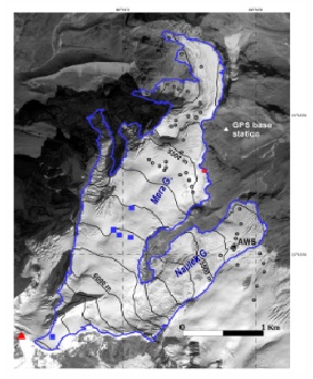
Mera Glacier (27.7° N, 86.9° E, 5.1 km2) is a debris-free glacier straddling Hinku valley and Hunku valley (Dudh Koshi basin, Everest region, central Himalaya), and has been monitored since 2007. Mera Peak is popular among the climbers because of its gentle slopes (mean slope of ~16°) and its 5 to 7 day access from Lukla airport.From the summit at 6420ma.s.l., the glacier flows north and divides into two main branches at 5800ma.s.l. The main branch flows north and then west down to its snout at 4940ma.s.l. while the second branch is northeast orientated with its lowest elevation at 5260ma.s.l. These two branches are referred as Mera and Naulek, respectively. Naulek is also part of the glacierized complex covering the northern slopes of Naulek Peak located ~3.5 km southeast of Mera Peak. Mera Peak is one of the most southern mountains of the region, and thus occupies a frontal position against the Indian monsoon flux.
Other Networks to Which This CryoNet Station Belongs
Observatory for Research on the Environment Glacioclim-Himalaya
World Glacier Monitoring Service
Measurement Methods Used
GTN-G/WGMS
Data Information
Are the data quality controlled? yes
How are the data accessible? HTTP (web)
Data availability (may depend on the variable measured): delayed less than one year
Publications
Wagnon P, C. Vincent, Y. Arnaud, E. Berthier, E. Vuillermoz, S. Gruber, M. Ménégoz, A. Gilbert, M. Dumont, J. M. Shea, D. Stumm, and B. K. Pokhrel. Seasonal and annual mass balances of Mera and Pokalde glaciers (Nepal Himalaya) since 2007. 2013. The Cryosphere, 7, 1769–1786, doi:10.5194/tc-7-1769-2013.
Measurements
The measurements made at Mera are listed in the following tables. (Note: If End Year is blank, measurements are ongoing.)