Snow Watch |
 |
The main goals of Snow Watch are to assess the maturity and accuracy of snow products, improve the reporting of and access to in situ snow measurements, promote the exchange of snow data and information for snow cover monitoring, and identify critical snow-related issues that need to be addressed in GCW. Snow Watch is making major advances in snow cover observation, monitoring and exchange of data and products from in-situ and satellite sources as part of GCW’s goal to provide authoritative cryospheric information. Team members are drawn from across the global snow community. The GCW Snow Watch project began in earnest with the First Snow Watch workshop in early 2013.
Current Snow Watch activities include:
- a satellite snow product validation and intercomparison project (ESA SnowPEX),
- a product inventory and self-assessment of products by principal investigators,
- a global snow data rescue project,
- "Snow Trackers" for snow cover extent and snow water equivalent (SWE),
- efforts to standardize snow-related nomenclature, and
- Improving reporting practices and real-time data for in situ snow measurements on the GTS network, enabling wider access to these observations. [More...]
Snow trackers have been developed for GCW by the Finnish Meteorological Institute and Environment Canada. They are available on the Trackers page as well as the Snow page of Cryosphere Now.

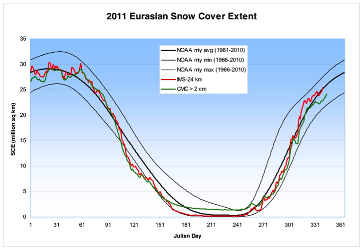
Intercomparison example - Plot of NH near real-time snow cover extent (SCE) from two operational snow analyses: the Canadian Meteorological Centre (CMC) daily snow depth analysis and the NOAA/National Ice Center Interactive Multi-Sensor Snow and Ice Mapping System (IMS) 24 km daily snow cover analysis. The “normal” range for SCE was determined from the NOAA monthly CDR product maintained at Rutgers University.
ESA SnowPEX: Satellite Snow Product Intercomparison and Evaluation Experiment
In part as a response to the recommendations put forth in the first GCW Snow Watch workshop, the European Space Agency (ESA) is supporting a snow product intercomparison study, called SnowPEX. The goal of SnowPEX is to assess the quality of current satellite-based snow extent and snow water equivalent products, and to develop guidelines for improvement. SnowPEX will obtain a quantitative understanding of the uncertainty in remotely sensed products through a coordinated and consistent evaluation exercise using ground reference measurements, high resolution optical imagery, and reanalysis and land surface model products.
Participating snow extent and snow water equivalent products, and details on reference datasets are available at http://snowpex.enveo.at. Project deliverables and supporting documentation are available at http://calvalportal.ceos.org/263.


